BOCONO FAULT BETWEEN SANTO DOMINGO AND SAN CRISTOBAL ¹
GENERAL INTRODUCTION :
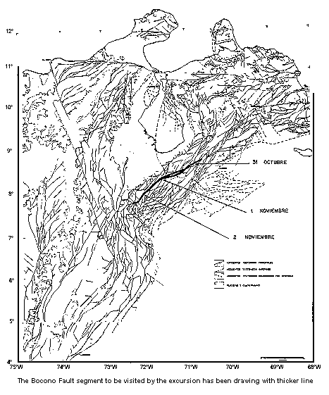
This excursion has the propose of showing to its participants specific neotectonic.characteristics of the Boconó Fault in the segment between Santo Domingo (Merida State) and San Cristobal (Tachira State). (Fig. Generalized tectonic synthesis).
This segment concentrates important geomorphological evidences of recent displacement which will be object of detailed field observations in diverse altitudinal and bioclimatic environments crossed by the active trace of this fault along three distinct sectors:
October 31st
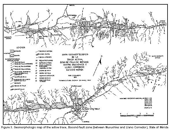
The Boconó Fault between Mérida and Santo Domingo (Mérida State)
Guide: C. Schubert
INTRODUCTION
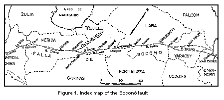
The Boconó fault zone, one of the most important geotectonic features of northwestern South America (Fig. 1), is morphologically characterized by an aligment of valleys and linear depressions (pull-apart basins), oriented in a approximate N45°E direction. It extends for over 500 km between the Táchira depression and the Caribbean Sea (Moron area, State of Carabobo), obliquely crossing the Mérida Andes and cutting the western end of the Caribbean Mountains (Cordillera de la Costa and Serranía del Interior). Along its whole extend, one or several active traces are found, called the Boconó fault, which is characterized by fault scarps, offset fluvial channels, sag ponds, shutterridges, and other typical geomorphic features od strike-slip faults. The present-day and former displacement along this fault zone has been the subject of great controversy.
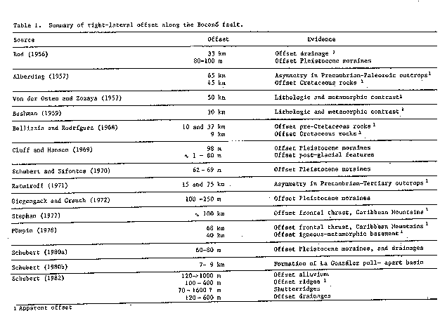
Emile Rod (1956a) was the first to describe and name the Boconó fault, which he considered a right-lateral strike-slip fault, and a part of a system of such faults in northern Venezuela: the Oca, Morón, and El Pilar faults. Since then, other authors have described geologic aspectos of the Boconó fault. Table 1 summarizes their principal conclusions corcerning strike-slip offset. The initial reports (Rod, 1956a; Alberding, 1957; von der Osten y Zozaya, 1959; Bushman, 1959) generated great controversy with respect to the nature of the Boconó fault, in the part because it is the best known of the three great Venezuelan fault zones, and more data exists about it. To resolve this controversy, the Asociación Venezolana de Geología, Minería y Petróleo held a round-table (Rod et al., 1958) to discuss all the evidencce of offset along the fault. The main conclusions of this round-table, which are still in great part valid today, were: 1. the Boconó fault has a pronounced topographical expression, and along most of its extent it is a fault zone, and not an individual fault; 2. its length is approximately 425 km (in 1958. Author's note), parallel to the central part of the Mérida Andes; 3. offset along the fault is reflected by the lithologic contrast across it, or by vertical offset of the same formation; 4. right-lateral offset is shown by Pleistocene features; 5. the fault's strike is frequently offset by oblique faults; 6. the fault's age varies (according to each author) from Late Cretaceous to Recent; 7. adjacent folding is, in general, parallel to the fault; and 8. along its lenght, recent earthquakes have occurred.
Rod et al. (1958) postulated three kinds of offset (that is, three kinds of faults): strike-slip, normal, and a combination of the two. Cluff y Hansen (1969), in an extensive report on the Boconó fault, showed that this fault has all the characteristics of a strike-slip fault.
Some authors have postulated mainly vertical or normal offset along the Boconó fault. Schubert (1968) described the fault in the Santo Domingo region and found evidence of vertical offset, with the formation of horsts and grabens. Grauch (1975), based on the continuity across the fault of the sillimanite isograd (Sierra Nevada Formation, Precambrian) in the Mucuchíes region, postulated mainly normal offset. Shagam (1972, 1975) considered that the Boconó fault was an extensive post-Paleozoic graben, along which important
vertical offset occurred, associated with the Late Tertiary to Quaternary uplift of the Mérida Andes. Giegengack et al. (1976) found evidence of the both types of offset, right-lateral and vertical or normal, during the Late Cretaceous. Weingarten (1977) described a paleo-oxisol at elevations of 1200 to 2200 m above the Chama river level, in the La González basin (south of Mérida9, which he interpreted as up-lifted far above its level of formation (Malagón, 1982, however, has presented data on soil formation in the páramos, which in part invalidate this interpretation). Finally, Schubert (1980b) postulated the existence of pull-apart basins, such as the La González basin, along the Boconó fault zone, filled with Quaternary sediments, which are characterized by large normal offset; these basins are separated by narrow fault zones, with mainly rigaht-lateral offset along them.
The effect of offset alonf the Boconó fault on Pleistocene features was studied recently by Schubert and Sifontes (1970, 1972), Giegengack and Grauch (1972a, 1972b), Giegengack et al. (1976), and Schubert (1980a, 1981, 1982). These authors describe offset geomorphic features in the high Chama, Santo Domingo, and Aracay river valleys. Among these, there are offset lateral moraines, which were deposited during the late stade of the Mérida Glaciation (Schubert, 1974), of Late Pleistocene age. Radiocarbon ages (Schubert, 1970; Schubert and Sifontes, 1970; Giegengack and Grauch, 1976; Salgado-Labouriau et al., 1977) suggest that these moraines have a minimum age of 13,000 C-14 years B. P., and a comparation with adjacent regions in Surth America, suggest a maximum age of 18,000 years B. P. Right-lateral offset varies between 60 and 100 m since the glaciers retreated from their terminal positions, and 250 m since the glacier of Quebrada La Mucuchache valley reach its terminal position for the first time (Giegengack and Grauch, 1972b). Based on these data, the right-lateral offset rate can be calculated as a maximum of 0.5 and 0.8 cm/year and a minimum of 0.3 and 0.6 cm/year, assuming that the offset is constant and not sporadic.
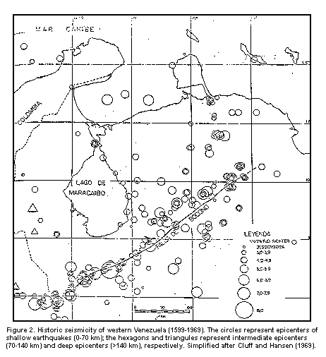
The seismic activity of the Mérida Andes has been analized by Fiedler (1970, 1972), who suggested that this activity can be subdivided into two periods: before and after the 1812 earthquake. The earthquake frequency seems to have increased after that event, but the liberated energy has not changed. Raúl Estevés, in a conference presented at the XXX Anual Convention of AsoVAC in Mérida, demonstrated that the number of earthquake with a magnitude greater than 5, between 1610 and 1945, is significantly greater near the northeastern and southwestern ends of the faukt (suggesting a greater activity at the ends, possibly because most of the offset is being taken up there), and that focal depths range from approximately 30 km near the ends of the fault to about 15 km at the center. The seismicity of the Boconó fault was studied in detail by Dewey (1972), who, on the basis of first motion analyses, showed that offset along it is consistent with an eastward displacement of the Caribbean plate with respect to South America, and also that the plate boundary is partially located along the Boconó fault (Molnar and Sykes, 1969; Schubert, 1970; Schubert and Sifontes, 1970). According to Dewey (1972), this boundary has included the Boconó fault since the Pliocene (approximately 5 million years age). The transverse orientation of the Boconó fault with respect to the cordillera, and also the fact that it crosses different geologic and tectonic provinces, is evidence that this fault is external to the Andes and that is joined the plate boundary in the Late Tertiary. Fig. 2 shows the historic seismicity of the Boconó fault, according to Cluff and Hansen (1969).
ITINERARY
Stops
1. Escagüey:
To the southeast, the trace of the Boconó fault can be seen cutting the hill south of Mucurubá. The hill has been offset several hundreds of meters in a right-lateral sense, and the traceis marked by a wedge and a saddle like pass..
2. El Vergel:
The fault trace forms a trench on the northwestern side of the road and cuts a hill which descends from the sierra towards Mucuchíes, offsetting it by several hundreds of meters, in a righ-lateral sense.
3. Mucuchíes:
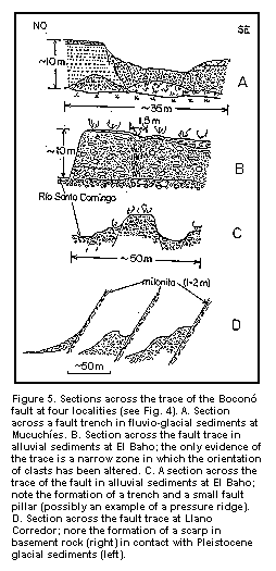
To the west, a fault depression filled by a swamp or peat bog can be observed. On both sides there are fault scarps. Towards the east, a crossection across the fault trace can be observed (Fig. 5), which continues to the northeast, towards La Toma. Between Mucuchíes and La Toma (along the mountain road) there are several depressions and fault scaps.
4. La Toma:
The fault trace cuts the alluvium of Quebrada La Toma, forming a scaps approximately 20 m high, on which the village of La Toma is located. From here, this trace turns to the north, passing near Llano El Hato and possible joining the Valera fault. Along this trace there are well defined fault scarps.
5. San Rafael:
Looking to the southwwest, one observes an alluvial cone cut by the trace of the Boconó fault, this time on the southeast side of the valley, forming a scarp 15 to 20 m high.
6. Quebrada El Caballo:
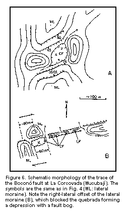
At this locality, the left lateral moraine of Quebrada El Caballo has been cut and offset 80 m in a right-lateral sense (Fig. 6). Behind the shutterridge formed by the offset moraine (to the north), a clossed depression was formed and the quebrada had to deviate by approximately 60 m to the right. To the northeast, the trace consists of a fault trech with several clossed depressions and sag ponds. Radiocarbon analyses of the top and botton sediments of these ponds suggests that the maximum age of these depressions is between 3800 and 4500 years B. P., that is, they are Holocene neotectonic features.
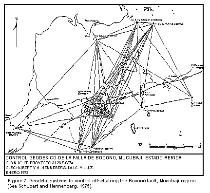
7. Mucubají:
The trace of the Boconó fault passes along the south shore of laguna de Mucubají, cutting the lateral moraines of the Quebrada Mucubají valley. It forms a trech south of the house of the Universidad de los Andes, with a small pond, and continues to the northeast forming scarps and trenches. In the Mucubají region, two geodetic systems have been installed (Fig. 7) to control the offset along the Boconó fault (Schubert and Henneberg, 1975): a. a primary system with 8 stations in rock, with distances between stations of several kilometers; and b. a secondary system, around laguna de Mucubají, with 8 stations in glacial sediments, with distances between stations of up to 1 km. Geodetic measurements between 1975 and 1981 (Hennenberg, 1982) have demostrated compressional movements of the two sides of the fault, with a lateral component (parallelto the fault) of 13 mm in 66 months, that is, an offset of 0.24 cm/year.
8. Morrena Victoria:
From the road to Santo Domingo, one can see the right lateral moraine of Quebrada Victoria, which has been cur and offset by approximately 70 m in a right-lateral sense (Fig. 6). This is the classic locality described by Emile Rod in 1956.
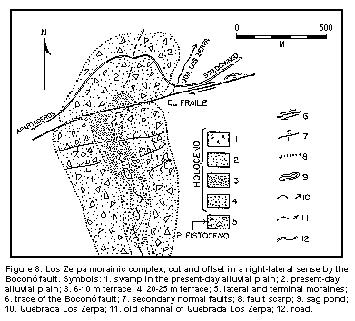
9. Morrena Los Zerpa (El Fraile):
At this locality, the trace of the Boconó fault cuts the lateral moraines of the Quebrada Los Zarpa valley, separating them from the terminal moraine (Fig. 8), which has been offset by approximately 70 m in a right-lateral sense (Schubert and Sifontes, 1970). Quebrada Los Zarpa originally drained through the terminal moraine, but at present flows along the fault trace to El Fraile and into the Santo Domingo river. In the Quebrada Los Zerpa valley there are two levels of fluvio-glacial terraces (Schubert, 1981): 6-10 m and 20-25 m. The 20-25 m terrace consists of fluvio-glacial conglomerates; the 6-10 m terrace consists of three facies, from north to south: a) a lacustrine facies with laminated clays in the lower part of the morainic valley; b) a deltaic facies in the central part; and c) a fluvio-glacialfacies in the upper part of the valley. This is interpreted in the folowing way: during the inicial phase of thedeglaciation, the morainic valley filled with fluvio-glacial sediments derived from the melting of the glacier. Then the terminal moraine was breached, possibly due to offset along the fault, the gradient of the quebrada steepened and it cut these fluvio-glacial sediments (20-25 m terrace). The breach closed, closing the valley again, and a lake formed in the lower part of the valley, are fluvio-glacial sediments were deposited higher in the form of a delta. The breach opened again in the terminal moraine, and the quebrada and the lake, which drained over the terminal moraine, cut another terrace (6-10 m terrace) and drained through the trace of the Boconó fault. To the southeast, at El Fraile, a well defined fault scarp and sag pond can be seen, the latter modified by man. More southeaswardly, the El Venado morainic complex can be seen, cut and displaced also by the Boconó fault (Giegengack and Grauch, 1976).
10. El Venado:
from the road to the south, the El Venado morainic complex can be seen, cur and offset by the Boconó fault.
11. El Baho:
Across from the El Baho trout farm, an alluvial cone deposited from the Sierra de Santo Domingo, has been cut and offset by the trace of the Boconó fault. The morphology is characterized by fault scarps, and fault pillars and depressions (Fig. 5).
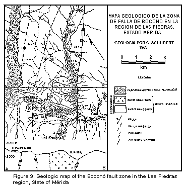
12. Las Piedras:
A view of the Aracay river valley towards the northeast. The trace of the Boconó fault cuts the southeastern slope of the valley, forming shutterridges and fault trenches (Fig. 9). If weather permits, the trace can be seen all the way to the páramo of Llano Corredor, which separates the basins of the Aracay and Burate rivers. In the high parts of the Aracay valley, the fault trace again cuts and offsets lateral moraines in a right-lateral sense.
13. La Mitísus:
An outcrop of a cataclastic zone in the Boconó fault zone, formed by approximately 100 m of crushed rock. Petrographic analyses showed that the original rock was gneis and schits of the Sierra Nevada Formation, similar to the rock inmediately to the southeast.
14. Represa "José Antonio Páez":
Panoramic view of the dam and the Aracay river valley.
RETURN TO MERIDA.
November 1st and 2nd
The Boconó Fault between Mérida and San Cristóbal (States of Mérida and Táchira)
Guides: A. Singer y J. P. Soulas
1. GEOMORPHOLOGICAL CONTROL OF ACTIVE FAULTS IN SOUTHERN ANDES.
The geomorphological expression of recent tectonic activity varies considerably along the Boconó fault system in the aspects of density and continuity of diagnostic evidences mapped in detailed.
This fact is also observed among diverse fault systems in the South of the Andes which were likewise mapped (Boconó System, South America Central System, Caparo System).
For a correct interpretation of these differences in the geomorphological expression for purposes of classification of the activity of these fault or segments of a given fault, it is necessary to take into account the intensivity of the morphogenesis susceptible of affecting fault ruptures in the different bioclimatic floors of the Andes (W. D. Cline, 1981; A. Singer y J. P. Soulas, 1981; C. Beltrán et al., 1983).
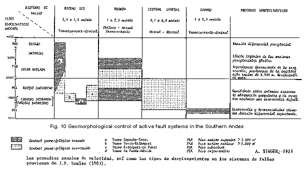
Figure 10 shows the distribution of the different segments of the Boconó Fault considered in this part of the excursion and other fault systems in the Southern Andes which are crossed by these in diverse morphogenetic environments, acording to the activity rates evaluated by geological criteria (J. P. Soulas, 1983) and according to the quality of the geomorphological control.
Geomorphological Control in active faults of Southern Andes.
In the middle and upper floors of the Andes, particularly above 2500 m. in height, the increassing deficit of precitations and the relatively discrete morphogenesis favors the conservation of many evidences of quaternary tectonic activity such as deformed moraines, offset draunage, tilt terraces, etc. For these reasons, the tectonic significance of the obtained evidences is factibilitated by a limited number of physiographic mimetics with fault rupture of geomorphological kind or of a different nature. Ambiguities can arise with occurence of gravitational phenomena (lateral spreading) as it cam be seen at Páramo La Negra and Portachuelo near Bailadores and Paso Zumbador, respectively. Such conditions explain the excepcional quality of the active faults traces with recent movement like the southern section of the Boconó Fault (5.5 to 5.7 mm/y) and others with lesser activity like Alto Uribante Fault (0.1 to 0.4 mm/y).
In the lower floors to The Andes the greater dynamism of the morphogenesis, linked to the volumen and intensity of rainfall, leads to hinder or eliminate the morphotectonic control of recent deformations by means of processes of differential erosion far more generalised than in upper floors. This explains the difficulties we face to evidence and diagnose recent movements along faults of relatively low rates of activity such as those of the Central South Andean System (0.1 to 0.9 mm/y). In the same way this fact can explain the fading of the active trace of the Boconó Fault as it passes though the west sections of the subandean floor, in particular between El Cobre and La Grita, between El Peñón (north of Tovar) and Estanquez, and between San Juan and La Punta (near Mérida). In these environments, as it was verified in the Uribante river, vertical tectonic deformation ranging several meters, ocurred some 37000 years ago and observed in suboil by means of trench excavations, cannot be recognised on surface because they have been erased by the morphogenetic action. In other cases, on the countrary, the morphogenetic action can work evidences under wet tropical conditions upon faults of moderate activity rates of 1.0 to 2.5 mm/y (class 3 of L. S. Cluff et al., 1983) as it is found along the fault valley of Caparo River for some 20 kilometers.
Among the different active fault systems in the southern Andes, The Boconó Fault constitutes the tectonic accident with greater transcurrent activity and physiographic importance as it is crearly seen in radar (SLAR) imagery. The particular nitid expression of this fault is due to the alignement of several drainage axes along it (River Chama, Mocoties, La Grita, El Valle and Torbes), and to the presence of longitudinal tectonic depressions that broarden the fault valleys (pull-apart of La González, Bailadores, Los Mirtos and Capacho).
The eviences of recent activity that characterize this fault system of Boconó between Mérida and San Cristóbal are divided according to their locations in the following segments:
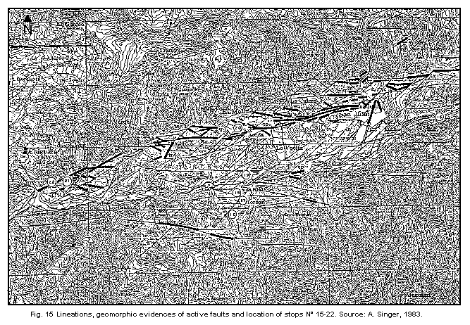
a) Evidences of active faulting in the sention La Punta - Mérida (Fig. 15).
From Tabay a double active fault trace borders the city of Mérida along the left side of the river Chama and showing typical evidences of transcurrent movement such as tectonic scarpments, offset drainage (right lateral), sag-pond and fault trenches. In the old zone of the city of Mérida there is a scarp of about 2,5 m on the top of the terrace (QII terrace) following a transversal strike to it and corresponding to a fracture branching ouy the main trace.
La Punta place belongs to the NE extremity of the traction basin of Estanquez-Lagunillas (pull-apart of La González. C. Schubert, 1980) and constitutes a fault nodus. The annexed figure shows that in this point the active trace of the Boconó Fault is crossed by another, probably active, fault (Mucujum-Albarregas Fault) to constitute the northern and southern borders of La González pull-apart. From the Sierra Nevada hill-sides, on the other hand, the deformation of the mesa can be seen clearly where a strong flexure is manifiest downstream.
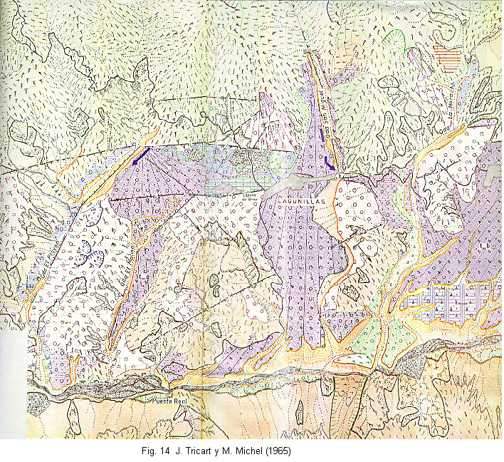
b) Evidences of active faulting in La González basin (Fig. 15).
Many important geomorphological manifestations of recent deformations accompany the active trace of the Boconó Fault along the north side of La González pull-apart, between Ejido and Chiguara. The most spectacular example of these deformations is the Laguna de Urao sagpond close to the village of Lagunillas. Such a trace of the Boconó Fault could coincide with a paleo-channel of the Chama river filled by deposits of the lower Pleistocene QIV (ex-conglomerate of Lagunillas according to the stratigraphic Lexicon of Venezuela, 1st edition) which appear strongly tectonized (J. Tricart, 1965).
In contrast with the trace of the north border, the Boconó Fault trace on the south border, shows little evidences of recent activity, running along the present channel of the Chama river. Nevertheless, existing deformations can be verified nearby such a fault trace; for instance, along linneations north of La Horcaz, in alluvium of old Quaternary suspended atop the fault scarp at Puente Real.
The geometry of La González pull-apart accentuated by the Boconó Fault traces is consistent with the right-lateral movement of this system.
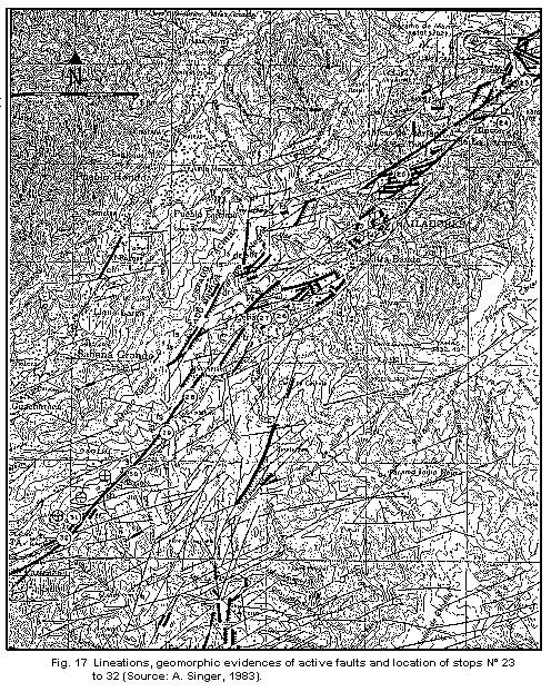
c) Evidences of active faulting in the section Tovar - La Grita (Fig. 17).
After the fault segment Chiguara-Villa Socorro where the active trace of the Boconó Fault loses its nitid expression and gets hindered by the channel of the Mocoties river, we found another segment with the very important evidences of recent movement between Tovar and La Grita.
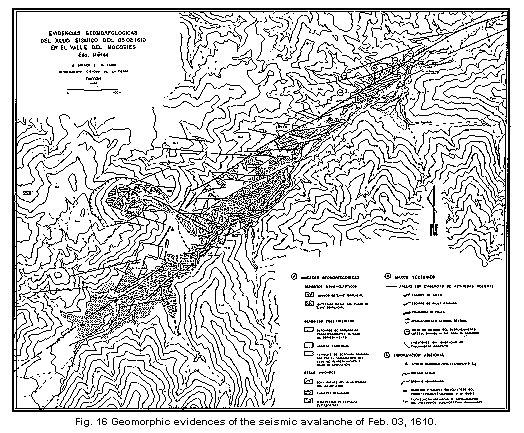
The geomorphological evidences mapped in Fig. 17, show the existente of some roughness in fault trace between Tovar and Portachuelo (divide between La Grita y Mocoties rivers). This is particularly observed between Tovar and Mesa Adrian, wherer the fault trace presents "en echelon" features towards the left. These features favour the concentration of stresses in the interruption zone of the fault in concordance with the right-lateral movement of the Boconó Fault evidenced, between Tovar and El Peñón, by characteristic displacements of the left tributaries of the Mocoties river. Such a concentration of energy could explain the size of geologic effects registered by the historical seismicity whose tracks are still present in some cases. The 1610 earthuake, for instance, caused an avalanche which dammed the valley of the Mocoties river at El Volcan, upstream Tovar. The scarp of this massive landslide is still fresh in Paramo Mariño. The extension of the lake formed is recognised clearly in the field and in aerial photographs, in the place known as Rincon de La Laguna (A. Singer, M. Lugo, 1982).
The "en echelon" pattern prolongates through a rhomboid depression (pull-apart) in the area of Bailadores which is associated to a slight bending of the main fault trace. Lots of deformations accentuated by fault trenches and movements of blocks are observed in this distensive structure. It also seems to favour phenomena of lateral spreading in The Paramo La Negra flank, west of Bailadores, that were mentioned firstly by D. H. Radbruch-Hall (in B. Voight, 1978) but wrongly located and indicated again by C. Giraldo et al., 1981.
Between El Portachuelo and La Grita, the active trace of the Boconó Fault shows a more even and linear patern with plenty of evidences of recent movement of the right-lateral type as it is seen, for example, in Las Porqueras.
From the pull-apart of Bailadores an active branch comes out the Boconó Fault to from the Alto Uribante fault. In its north segment this fault shows many scrapments of a normal type, (verified in the field). These dislocate the old quaternary fanglomeratic deposits which fill the solution pits of La Casona and El Hato in Paramo de Viriguaca formed by geochemical alteration of late Tertiary (Pliocene). In its south segment, the same fault crosses the Paramo La Cimarrona (periglacial) where some fresh fault planes and a moraine, probably deformed, north of LAs Mellizas pond give good evidences.
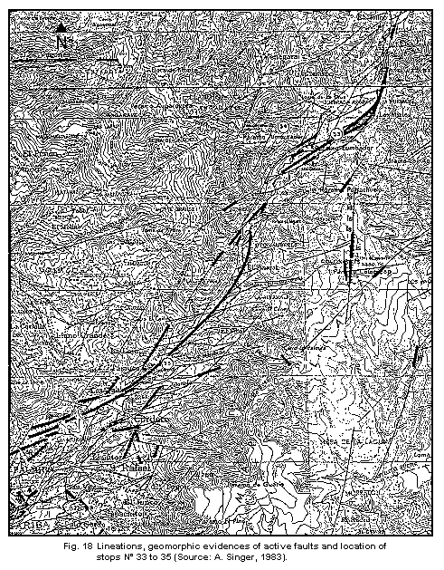
d) Evidences of active faulting between La Grita and Capacho.
South of La Grita, the active trace of the Boconó Fault joins the southward prolongation of Rio Escalante fault. From La Grita as far as El Cobre the geomorphological evidences of active faulting lose continuity and are probably hindered by morpho-climatic conditions.
Between Paramo El Zumbador and Capacho the Boconó Fault shows again a continous active trace marked by many local examples of deformation. Right-lateral movement exemplifications are: pull-apart of Los Mirtos, fault trench of Fundo Los Cedros, shutter-ridge and sag-pond of the Late Pleistoceno QI at Sabana Larga, sag-pond of Palmira and the pull-apart of Capacho.
2. SISMOTECTONIC MODEL (J. P. SOULAS, 1983).
In the middle of southern Venezuela Andes, the Boconó Fault, right-lateral type, abandons the axial position it had in the mountain volume in the north, to run along the western flank of the mountain range. This migration is accompanied by a good deal of structural complocations, such as: torsions, "echelons", branchings, pull-apart, secondary faults, etc.
The Caparo system, also right-lateral, runs symmetrically to the Boconó one, on the eastern flank of the Andes. It shows numerous complications like those observed in the northern part of the depression of the Caparo river, where an oblique segment of the fault propiciates a contact with inverse faulting between two blocks. In the southern part, it is complicated by extensive branching.
The Central South-Andean system is located between Boconó and Caparo faults and does not show the continuity of them, for it subdivided in two parts: one north and one south, whitout apparent connection between them, for it subdivides in two parts: one north and one sout, without apparent connection between them. The south segment, of right-lateral type, branches to wards the middle part of the system where it is softened by dominant normal faulting.
It is probable that both Central systems and the Caparo one write with the Boconó Fault northeast of Santo Domingo. Both also tend to join southwards when they reach the Bramon transversal (NO-SE) system.
Figures 11 and 12 give a visualization of the model of active tectonics of southern Andes.
The oblique convergence ogf the Caribbean and South American plates along the Boconó Fault (main plate boundary) produce two kinds of effects (J. P. Soulas and Y. P. Aggarwal, 1982).
The first is a shortenning between the two blocks, which generates faulting located to the outer part of the mountain range (inverse front system) and on the other hand, the bumping of the present mountain volumen. This bumping induce a traction in its external arch and a compression in its internal arch. The first has as a consecuence the normal faulting observed in the surface, and the second the inverse faulting detected at depth (D. García, Y. P. Aggarwal, 1982). The inverse faulting has focuses deeper than 8 kilometers, distance that must correspond approximately to the location of the neutral surface which separates traction from compression.
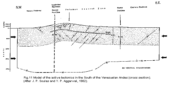
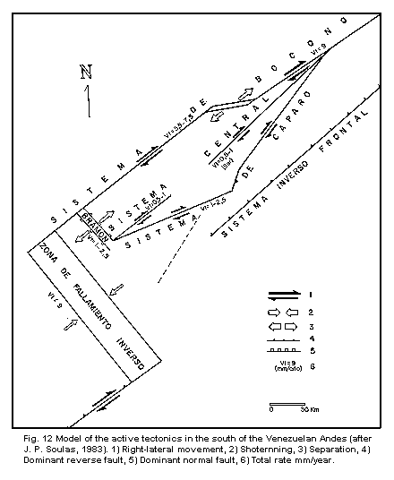
The second effect of the oblique convergence between these plates is the horizontal, right-lateral displacement of the two blocks separated by the Boconó system and the equivalent system probably located close to the Oriental Mountain range of Colombia. These main movements have as a consequence the stocking between the two places about the zone of inverse faulting (Fig. 12).
On the other hand, the existence of the Central South Andean System and the Caparo system means a decrease in the slip-rate in the southern part of the Boconó Fault, in such a way that adding up the slip-rates of Boconó, Central and Caparo must be equal to the slip-rate of the Boconó Fault alone in its segment to the north.
The Caparo and Central South-Andean systems soften southward in the predominantly normal faulting of the Bramon System.
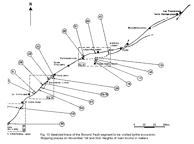
3. ITINERARY (FIG. 13)
8:00 a.m.               Salida del Hotel La Pedregosa (Mérida)

8:20 - 9:00 a.m.        Stop N° 15: La Vega. Widest part of the semi-arid
                        traction basin of La González which shows an
                        exceptional character in the Boconó System both
                        climatic and tectonically. General characteristics
                        of the alluvial covers QIII, QII and QI.

9:35 - 10:20 a.m.       Stop N° 16: Fault saddle of La Horcaz, in the road
                        to Pueblo Nuevo. La Horcaz N° 1. Panoramic view over
                        the tectonic depression of La González. Location of
                        quaternary alluvial units whitin the landscape.
                        Residual morphology, and characteristics of the
                        alluvial deposit QIV suspended in southern flank
                        of the depression. Tectonic origen of the present
                        differentiation of the mountain volume.
10:25 - 11:00 a.m.      Stop N° 17: La Horcaz N° 2. Comments of the
                        tectonics of La González traction basin. Location of
                        the main accidents, developments mechanisms,
                        conclusion on the tectonics of the Boconó Fault
                        (rate, age, etc.).

11:05 - 11:20 a.m.      Stop N° 18: La Horcaz N° 3. QIV Sediments, offset by
                        small and medium size normal faults.

11:35 - 12:00 a.m.      Stop N° 19: Nearby Puente Real. Evaluation of throw
                        at the level of the fault system in the southern
                        edge of the traction basin.

12:10 - 12:30 p.m.      Stop N° 20: Lagunillas. The Urao sag-pond and fault
                        scarpment in the Quaternary QIV.

12:35 - 13:35 p.m.      Lunch: Lagunillas.
14:00 - 14:30 p.m. Stop N° 21: El Llano N° 1. Active trace of the
Boconó fault in the northern flank of the traction
basin.
14:35 - 14:55 p.m. Stop N° 22: El Llano N° 2. Western extremity of the
traction basin (zone of Estanquez - San Felipe).
15:50 - 16:40 p.m. Stop N° 23: El Campito. Remmants of the seismic
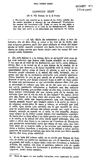
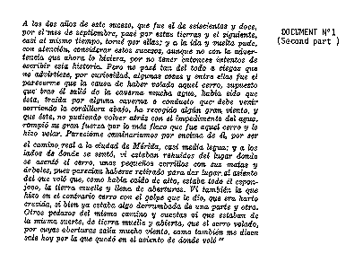
avalanche of Feb. 03, 1610 at El Volcán (Fig. 16).
Morphology of the proximal deposits. Source basin
(see document N° 1).
16:50 - 17:20 p.m. Stop N° 24: Rincón de La Laguna. Lateral damming of
the Mocoties Velley by proximal deposits from the
seismic avalanche of the Feb. 03, 1610 earthquake.
Extension and remmants of the dammed lake.
17:40 - 18:10 p.m.      Stop N° 25: Bodoque. Tectonic complexity of the
                        Bailadores zone. Land-slide of 1610. Bumping of La
                        Culata range (if weather is fine).

18:30 p.m.              Arrival to VEL Hotel: Bailadores.
7:00 a.m.               Salida del Hotel VEL: Bailadores.

7:25 - 8:00 a.m.        Stop N° 26: La Cebada N° 1. Identification of
                        several traces of the Boconó system north of
                        Bailadores.

8:10 - 8:30 a.m.        Stop N° 27: La Cebada N° 2. Fault trech of La
                        Cebada.

9:10 - 9:25 a.m.        Stop N° 28: North-east of Portachuelo. Panoramic
                        view over the eastern trace of the Boconó system
                        north of Bailadores.

9:35 - 9:55 a.m.        Stop N° 29: South-West of Portachuelo. Panoramic
                        view over the Boconó fault trace in the zone of Las
                        Porqueras.

10:10 - 10:30 a.m.      Stop N° 30: Las Porqueras. Offset drainage with
                        antecedents.

10:50 - 11:05 a.m.      Stop N° 31: North of La Montaña Hotel N° 1. Fault
                        trace with some evidences and location of point N°
                        32.

11:10 - 11:35 a.m.      Stop N° 32: Boconó Fault outcrop. Fault gouge.

12:30 - 13:00 p.m.      Lunch: El Cobre.

13:25 - 13:40 p.m.      Stop N° 33: Los Mirtos. Panoramic view over the
                        traction basin of Los Mirtos.
13:50 - 14:10 p.m.      Stop N° 34: Páramo Almorzadero. Panoramic view over
                        the "en echelon" zone of Los Cedros.

15:20 - 15:40 p.m.      Stop N° 35: Sabana Larga. Shutter ridge.

17:00 p.m.              Aeropuerto San Antonio. Return to Caracas.
REFERENCES
Alberding, H., 1957. Application of principles of wrench fault tectonics of Moody and Hill to northern South America: Geol. Soc. America Bull., 68: 785- 790.
Bellizzia, A. y D. Rodríguez, 1968. Consideraciones sobre la estratigrafía de los Estados Lara, Yaracuy, Cojedes y Carabobo, Bol. Geol., 9(18): 515-563.
Beltrán, C.; A. Singer y J. P. Soulas, 1983. Discriminación entre evidencias diágnosticas y evidencias ficticias de fallamiento activo en ambiente tropical húmedo, Simposio de Neotectónica, sismicidad y Riesgo Geológico en Venezuela y El Caribe. Acta Científica Venezolana Vol. 34., Supplto. N° 1, p. 522.
Bushman, J. R., 1959. Geology of the Barquisimeto area - a summary report: Bol. Inf., Asoc. Ven. Geol. Min. y Petról., 2: 64-84.
Cline, K. M.; L. Hutchings; W. D. Page y J. Jaramillo, 1981. Quaternary tectonics of Northwest Colombia. Revista CIAF, 6(1-3): 113-114.
Cluff, L. S.; K. J. Coppersmith y P. L. Knuepfer, ????. Assessing degrees of fault activity for seismic microzonatio, Tercera Conferencia de Microzonificación, 1: 113-118.
Cluff, L. S. y W. R. Hansen, 1969. Seismicity and Seismic-Geology of Northwestern Venezuela, Volume I, Evaluation. Woodward Clyde & Associates, para Shell de Venezuela.
Cluff, L. S. y W. R. Hansen, 1969. Seismicity and seismic geology of northwestern Venezuela: Compañía Shell de Venezuela, II.
Dewey, J. W., 1972. Seismicity and tectonics of western Venezuela: Seism. Soc. America Bull., 62: 1711-1751.
Fiedler, G., 1970. Die seismische Aktivitat in Venezuela im Zusammenhang mit den wichtigsten tektonischen Bruchzonan: Geol. Rundsch., 59: 1203-1215.
Fiedler, G., 1972. La liberación de energía sísmica en Venezuela, volúmenes sísmicos y mapa de isosistas; Bol. Geol., Pub. Esp. 5, 4: 2441-2462.
García, D. y Y. P. Aggarwal, 1982. Seismotectonics of Southern Venezuelan Andes. A.G.U. Fall Meeting, San Francisco. E.O.S., 63(45): 1126 (abstract).
Giegengack, R. y R. I. Grauch, 1972-a. Boconó fault, Venezuelan Andes (discussion): Science, 175: 558-560.
Giegengack, R. y R. I. Grauch, 1972b. Geomorphologic expression of the Boconó fault, Venezuelan Andes or geomorphology to a fault: Abstracts with programs, Geol. Soc. America, 4: 719-720.
Giegengack, R. y R. I. Grauch, 1976. Late Cenozoic climatic stratigraphy of the Venezuelan Andes: Bol. Geol., Pub. Esp. 7, 2: 1187-1200.
Giegengack, R.; R. I. Grauch y R. Shagam, 1976. Geometry of Late-Cenozaic displacements along the Boconó fault, Venezuelan Andes: Bol. Geol., Pub. Esp.7, 2: 1201-1226.
Giraldo, C.; C. Rojas y B. Sauret, 1982. Evidencias de deformaciones gravitacionales profundas en la región de Bailadores - La Grita (Páramo La Negra y El Rosario, Edis. Mérida y Táchira, Andes Venezolanos). Libro Resúmenes XXI Convención AsoVAC, p. 212.
Grauch, R. I., 1975. Geología de la Sierra Nevada al sur de Mucuchíes, Andes venezolanos: una región metamórfica de alumino-silicatos: Bol. Geol., 12(23): 339-442.
Hennenberg, H. G., 1982. Geodetic Control of Neotectonics in Venezuela: Informe presentado en la Reunión de la Internacional Association of Geodesy, Tokyo.
Malagon, D., 1982. Evolución de suelos en el páramo andino (N. E. del Edo. Mérida, Venezuela): Informe SC-56, CIDIAT, Merida, 222 p.
Molnar, P. y L. R. Sykes, 1969. Tectonics of the Caribbean and Middle America regions from focal mechanisms and seismicity: Geol. Soc. America Bull., 80: 1639-1684.
Radbruch-Hall, D. H., 1978. Gravitational creep of rock masses on slopes, in Voight, B. (Editor): Rock slides and avalanches, 1, 607-657, Elsevier.
Ratmiroff, G. de, 1970. Late Cenozoic imbricate thrusting in Venezuela Andes: Am. Assoc. Petrol. Geol., Bull., 55: 1336-1344.
Rod, E., 1956. Strike-slip faults of northern Venezuela: Am. Assoc. Petrol. Geol. Bull., 40: 457-476.
Rod, E.; C. Jefferson; E. Von Der Osten; R. Mullen y G. Graves, 1958. The determination of the Boconó fault: Bol. Inf., Asoc. Ven. Geol., Mín. y Petról., 1: 69-100.
Salgado-Labouriau, M. L.; C. Schubert y S. Valastro, 1977. Paleoecologic analysis of a Late Quaternary terrace from Mucubají, Venezuelan Andes: Jour. of Biogeog., 4: 313-325.
Schubert, C., 1968. Geología de la región de Barinitas-Santo Domingo, Andes venezolanos surorientales: Bol. Geol., 9(19): 183-261.
Schubert, C., 1970-a. Venezuela y la "nueva tectónica global": Acta Cient. Venezolana, 21: 13-16.
Schubert, C., 1970-b. Geología glacial del alto río Santo Domingo, Andes venezolanos; Bol. Inf., Asoc. Ven. Geol., Min. y Petról., 13: 233-261.
Schubert, C., 1974. Late Pleistocene Mérida Glaciation, Venezuelan Andes: Boreas, 3: 147-152.
Schubert, C., 1980-a. Morfología neotectónica de una falla rumbo-deslizante e informe preliminar sobre la falla de Boconó, Andes merideños: Acta Cíent. Venezolana, 31: 98-111.
Schubert, C., 1980-b. Late Cenozoic pull-apart basins, Boconó fault zona, Venezuelan Andes: Jour. of Struct. Geol., 2: 463-468.
Schubert, C., 1981. Evolución post-glacial de un valle morrénico, Andes merideños: Acta Cient. Venezolana, 32: 151-158.
Schubert, C., 1982. Neotectonics of Boconó fault, western Venezuela: Tectonophysics, 85: 205-220.
Schubert, C. y H. G. Henneberg, 1975. Geological and geodetic investigations on the movements along the Boconó fault, Venezuelan Andes; Tectonophysics, 29: 199-207.
Schubert, C. y R. S. Sifontes, 1970. Boconó fault, Venezuelan Andes: evidence of postglacial movement; Science, 170: 66-69.
Schubert, C. y R. S. Sifontes, 1972. Boconó fault, Venezuelan andes (reply): Science, 175: 560-561.
Shagam, R., 1972. Evolución tectónica de los Andes venezolanos: Bol. Geol., Pub. Esp. 5, 2: 1201-1261.
Shagam, R., 1975. The northern termination of the Andes: In: Nairns, A.E.M. & Stehli, F.G. (Eds.) The ocean basins and Margins, v.3, The Gulf of Mexico and the Caribbean: Plenum Press, New York, p. 325-420.
Singer, A. y J. P. Soulas, 1981. Control geomorfológico de fallas activas en los pisos húmedos de los Andes tropicales venezolanos (Región Uribante-Caparo), Libro Resúmenes XXXI Convención AsoVAC, p. 212.
Singer, A. y M. Lugo, 1982. El alud sísmico del 3-02-1610 en el Valle de Macoítes (Andes Venezolanos). Confrontación de los testimonios del Siglo XVII y de las evidencias de campo actuales, XXXIII Acta Científica Venezolana, Supplto. 1, Resumen, p. 214.
Singer, A., 1983. Estudio de Riesgo Sísmico, Proyecto Uribante-Caparo, FUNVISIS, Informe Final, 1: 1-14.
Soulas, J. P., 1983. Tectónica cuaternaria de la mitad Sur de los Andes Venezolanos - Grandes rasgos. XXXIII Convención AsoVAC. Caracas. XXXIV Acta Científica Venezolana, (1): 525. Resumen.
Soulas, J. P. y J. P. Aggarwal, 1982. Recent tectonics of Southern Venezuela Andes: Geological and Seismological data. A.G.U. Fall Meeting, San Francisco, E.O.S., 63(45): 1125-1126. (abstract).
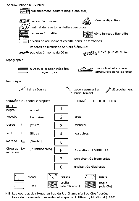
Tricart, J. y M. Michel, 1965. Monographie et carte Géomorphologique de la région de Lagunillas-Andes Vénézuéliennes. Rev. Geomorpho. Dyno, XV année, (1,2,3): 1-33, Paris.
Von Der Osten, E. y D. Zozaya, 1959. Geología de la parte suroeste del Estado Lara, región de Quíbor (Carta 2308); Bol. Geol., 4: 3-52.
Weingarten, B., 1977. Tectonic and paleoclimatic significance of a Late Cenozoic red-earth paleosol from the central Andes, Venezuela: Abstracts, 8th Carib. Geol. Conf., Curacao, p. 221.
¹ C. Schubert*; A. Singer** and J. P. Soulas**, 1983. Excursion: Boconó fault between Santo Domingo and San Cristobal, FUNVISIS, Simposium Neotectonics, Seismicity and Geologic Hazard in Venezuela and the Caribbean, XXXIII Anual Convetion of AsoVAC, 62 p.
* I.V.I.C. - Center of Ecology - Caracas.
** FUNVISIS - Departament of Earth Sciences - Caracas.