GUIDE TO THE FIELD TRIP L-3 TO EOCENE FLYSCH OF MARGARITA ¹
VI CARIBBEAN GEOLOGICAL CONFERENCE
EXCURSION GUIDE L-3
GUIDE TO THE FIELD TRIP L-3 TO EOCENE FLYSCH OF MARGARITA ¹
VI CARIBBEAN GEOLOGICAL CONFERENCE
EXCURSION GUIDE L-3
Objectives
The main purpose of this field trip is to offer to the VI Caribbean Conference delegates the opportunity of visiting some outcrops of the Eocene Flysch of Margarita Island, at present under study, and to observe turbiditic calcarenite beds, composed almost entirely of graded orbitoids, with their Bouma dlivisions as paralel and convolute laminations. Some of these limestone horizons are here called alodapic limestones because of their similarity to the ones described by Meischner (1964).
They could also see: greywacky sandstone sequences, turbidite proximal and distal facies, good exemples of primary sedimentary structures, as sole markings; and penecontemporaneous deformational, as slumping.
Good sites of chaotic deposits and parauthoctonous units gravitationally folded and slid within the same basin.
Scope of this Guide
This Guide is actually only a proyress report of a detailed and systematic investigation of the sedimentology of Margarita Flysch that his author is currently engaged in.
Antecedents
The area was originally studied and mapped by Universidad Central geology students in 1949, using arid subdividing the Punta Carnero Group that has been previously mentioned by C. González de Juana (1947). This unpublished subdivision appeared later in the Stratigraphical Lexicon of Venezuela (F. Rivero, 1956) from base to top, Las Bermudez Fm., El Datil Fm., and Punta Mosquito Fm. Kugler (1957) considered Punta Carnero as a formation with five members. Jam and Méndez A. (1962) published the Geology of Margarita and used the U.C.V. student formation names. Bermúdez and Gámez (1966) used the same names in their paleontological study of an eocene section of Margarita. González de Juana (1968) in his Guidebook of a field trip to the Eastern Margarita, offered a comprehensive summary of the Margarita Eocene knowledge and made stand out the importance of the different outcropping areas of Las Marites and Pampatar. More recently A. Paiva (unpublished Essay, 1969) made a local contribution to the petrographic knowledye of the area informing above its flysch character. This character is found first recognized in the Second Edition of the Venezuelan Stratigraphical Lexicon (1970, p. 651).
The knowledge of the Margarita Eocene has been mainly based upon the field geology courses of Univ. Central made in 1949, and upon some petroleum geologists' reconaissances with prevailing paleontological and stratigraphical points of view for mapping purposes. During the 1968 González de Juana's field trip to Eastern Margarita, Gonzalo Gamero and this present author observed clearly turbiditic sequences and expressed their doubts on the real meaning of the orbitoids rising the authorts determination of doing a sedimentological detailed study, incited ther by Professor C. González de Juana. This study is now in a laboratory phase.
As a logical result of this study, the author finds discrepancies with most published work on the Margarita Eocene. And since this is only a progress report the reader will not find stratigraphic columns or geologic maps. For this purpose the reader will find excellent illustrations in González de Juana's Guidebook (1968).
Brief Stratigraphic Summary
The Margarita Eocene is formed by Punta Carnero Group subdivided from base to top in: Las Bermudez Fm., El Datil Fm., and Punta Mosquito Fm. they all are parts of a flysch sequence, where turbidites of Calcarenites, Calcirudites and Calcisiltites stand out with orbitoids as their principal components; Bouma divisions; and some typical sedimentary primary structures.
The Group is known for a basal conglomeratic sequence with blocks, cobbles and alternating sandfones and shales (Fm. Las Bermúdez); an intermediate unit of thinly bedded shale and calcarenite, and calcisiltites, with graded orbitoidal subgreywackes and also alternating pelagites (El Datil Fm.); the uppermost unit of Punta Mosquito Fm. is a monotonous thin bedded alternating sequence of orbitoidal calcarenites and pelagic shales.
VI CARIBBEAN GEOLOGICAL CONFERENCE
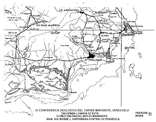
Local Field Trip L-3
Some outcrops of the Eocene Flysch of Margarita
Km. Time (P.M.)
0 1:00 Depature from Bella Vista Hotel. Drive along
Avenida Nueva Esparta.
0.7 1:04 Turn to the right to Avenida Aeropuerto.
At the intersection continue to
Los Robles and Pampatar.
4.9 1:12 Passing Los Robles entrance you can see
in front of you the Pampatar hills which
are formed by a flysch sequence of the
Punta Carnero Group.
5.1 1:13 At the crossroads turn to your right to
Bahia de Moreno.
From this point you can see (at 12 o'clock)
the area of Punta Moreno. At 2 o'clock see
the Morro de Porlamar.
7.5 1:20 STOP N° 1. Punta Moreno.
(30 minutes).
Good outcrops of: Lithologically and granu-
lometrically heterogeneuos conylomerate
with andesitic blocks, boulders and pebbles
of chert, quartz, metamorphic rocks,
limestone reef and fragments of limestone
beds, etc.; lenticular conglomerates and
shales; pseudonodules in calcarenites;
greywacky sandstones; fine paralel and
convolute lamination; interval of alterning
turbiditic sandstones and shales.
This coarse sequence of Punta Moreno belongs
to Las Bermudez formation, basal unit of the
Punta Carnero Group showing the beginning of
the rapid sedimentation towards the basin
caused by the tectonic instability during
the Eocene.
Walk to El Angel Site and return to the bus
through the beach.
8.1 1:50 Heading to Pampatar.
9.0 1:55 Lookins at 1 o'clock you can see Matasiete
(the highest hill) formed by Sodic Granite.
12.0 1:58 Pampatar City
13.3 2:02 To your left, a colonial temple of the XVIII
century. To your right you can see the San
Carlos de Borromeo Fort, built in the XVII
century.
13.5 2:04 Right turn. Broadcast station.
14.3 2:05 Pampatar Terminal. Fortin La Caranta.
Continue to Punta Ballena hills in order to
observe the monotonous alternating flysch
sequence.
Excursionists may take a look from inside
the bus to Pampatar Bay, Punta Moreno
(previous stop), and Morro de Porlamar.
2:12 Continue to next stop.
16.3 2:15 Right turn to unpaved road.
17.7 2:22 Left turn to Cueva El Bufón.
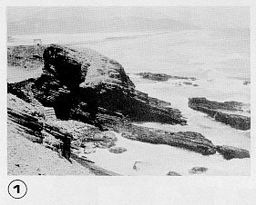
18.0 2:25 STOP N° 2. Touristic and Geologic Site.
Cueva El Bufón. (20 Minutes).
This is a very much visited tourist site,
because of its beautiful view.
The purpose of this s op is to take a
look at the cliffs with rithmic stratifi-
cation, a beautifu1 example of a thin
bedded monotonous sequence of normal
flysch considered the upper unit of
Punta Carnero Group (Punta Mosquito Fm.)
This unit represent a distal turbidite
facies. Here, the sandstones and siltites
are more greywacky than orbitoidal, and
you can see that the turbiditic sedimen-
tation units are very thin.
Note the larerally extended tabular cha-
racter of bedding (See Photo N° 1).
2:45 Back to the Bus.
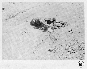
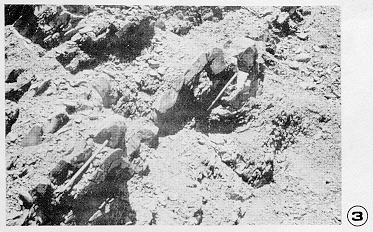
20.3 3:00 STOP N° 3. Salina de Pampatar.
(20 minutes).
Submarine gravity sliding features:
chaotic deposits formed by messy hetero-
genous clays (shales) with exotic cobbles
and boulders or olistoliths (See Photo
N° 2) and slumping (See Photo N° 3).
This unit probably represents a more
proximal turbidite facies where a steep
slope existed.
3:20 Return to the bus and back to Pampatar
and Avenida Aeropuerto of Porlamar.
30.0 3:50 Crossroad with Avenida Nueva Esparta,
Continue along Av. Aeropuerto, pass in
front of Porlamar Hospital. Go to Calle
Marcano. Left turn to Calle Guevara.
31.2 3:54 Bolivar Square and Temple.
Right turn to Calle Zamora to leave
Porlamar.
32.4 4:00 Gas Station. Road to Punta de Piedras.
32.8 4:01 The road cuts low hills of weathered
schists and phyllites of Los Robles Group.
34.0 4:05 At 3 o'clock site, a quarry on El Piache
Limestone of Los Robles Group for crushed
stones.
There you can see an oustanding dip slope
of El Piache Limestone.
35.8 4:08 Left turn to Las Marites
37.4 Beach dunes, to our left.
To our right Las Marites Lagoon with its
mangroves.
The road paralels the water pipeline
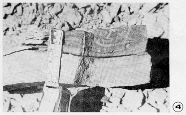
50.0 4:30 STOP N° 4. Punta Mosquito zone.
45 minutes walk along beach and coastal
outcrops. An opportunity to observe:
calcarenitic orbitoidal turbiditic
sequences with Bouma divisions (See Photo
N° 4); greywacky sandstones with fragments
of rocks, chert, quartz, and bioclasts;
plant remains mostly associated with the
paralel laminated division.
                      You can also see intrafolded sequences
                      of coarse and graded calcarenites, and
                      conglomerate graded beds with rock
                      fragments, chert, quartz, and reef
                      bioclasts; this disturbed sequence could
                      well be a gravitationally folded and
                      slid unit within the same basin, probably
                      coming from a more proximal turbidite
                      facies.
                      In most of the bioclastic turbidite cal-
                      carenite the following fossils have been
                      identified: coral algae, Lepidocyclina
                      spp., Lepidocyclina pustulosa, Eurupertis
                      sp., Discocyclina sp., Asterocyclina sp.,
                      Nummulites sp., etc. of an Upper Middle
                      Eocene (*)

             5:15     Back to the Bus and return to Porlamar,
                      Hotel Bella Vista.

         5:45-6:00    Arrival.

                      END OF THE FIELD TRIP

(*) Micropaleontological identification by Max Furrer.
Final Remarks
To the west of stop 4, in the same coast of Punta Mosquito, and in the area South of Los Bagres, there are within the flysch section several intervals with the appearance of real limestone beds, which are formed almost entirely of graded orbitoids deposited in turbidite sequences. They are distintive mapping horizons called here alodapic limestones because of their similarity with the ones described by Meischner (1964). Previously they were mapped as different stratigraphic orbitoidal levels.
Finally, the Eocene deposits of Margarita have all, flysch characteristics and their outcrops reelect different basin positions as proximal and distal turbidite facies, with all their characteristic primary structures: sole markings, Bouma divisions, grading, pelagite intercalations, etc. There are also intervals of very coarse textural flysch, features of submarine sliding, and gravitationally folded intervals slid within the same basin.
References
Bermúdez, P. y H. Gámez, 1966. Estudio paleontológico de una sección del Eoceno. Grupo Punta Carnero de la Isla de Margarita, Venezuela, Soc. Cienc. Nat. La Salle, Mem. XXVI, (75): 205-209.
González de Juana, C., 1947. Elements of diastrophic history of northeastern Venezuela; Geol. Soc. Amer. Bull., 58(8): 689-702.
González de Juana, C., 1968. Guía de la excursión geológica a la parte oriental de la Isla de Margarita (Estado Nueva Esparta). Asoc. Venez. Geol., Min. y Petról., Guía, 30 p.
Jam, L., P. y M. Méndez A., 1962. Geología de las islas de Margarita, Coche y Cubagua. Soc. Cienc. Nat. La Salle, Mem., 22(61): 50-93.
Kugler, H. G., 1957. Contribution to the geology of the islands Margarita and Cubagua, Venezuela. Geol. Soc. Amer., Bull., 68(5): 555-566.
Meischner, K. D., 1964. Allodapisch Kalke Turbidite in Riff-Nahen Sedimentations-Becken en: A. Bouma and A. Brouwer (Editors) Turbidites Elsevier, Amsterdam, pp. 156-191.
Ministerio de Minas e Hidrocarburos, 1970. Léxico Estratigráfico de Venezuela. Bol. Geol,. Publ. Esp. 4, 756 p.
Paiva, A., 1969. Contribución al estudio de las rocas del Eoceno de la Isla de Margarita, Edo. Nueva Esparta (informe inédito). Dpto. de Geología, Universidad Central de Venezuela.
Rivero, F. de, 1956. Grupo Punta Carnero en: Léxico Estratigráfico de Venezuela, Ministerio de Minas e Hidrocarburos, Pub. Esp. N° 1, pp. 532-535.
Universidad Central de Venezuela, 1949. Trabajos Inéditos. Alumnos de Geología, Caracas, Venezuela.
¹ Nicolás Gerardo Muñoz J., Universidad Central de Venezuela, Departamento de Geología, 6-11 July 1971.