FIELD TRIP TO TOAS, SAN CARLOS AND ZAPARA ISLANDS ¹
April 3, 1960
by Rudolf Blaser,
Cía. Shell de Venezuela,
and Arthur N. Dusenbury, Jr.,
Creole Petroleum Corporation
Introduction
This guide book provides the plan and topical outline second field trip of the Sociedad Geológica de Venezuela Occidental. Toas Island is its principal destination and it is schuduled for Sunday, April 3, 1960. The most important sections and localities will be visited, although it should be realized that not everything of interest on this geologically complicated island can be seen in part of one day.
This book may serve in the future for individual or group excursions to Toas Island. If launches are not available, such excursions can proceed by automobile from Maracaibo north to the town of San Rafael de Moján, whence a launch ferry service carries passengers to and from the town of El Toro there are several taxis which can be hired for Bs. 10 per hour.
For the scheduled trip of the Sociedad Geológica de Venezuela Occidental, members and guests will assemble at the Mene Grande Oil Company's dock in Maracaibo in sufficient time to purchase guide books and embark at 7:00 A.M. on Sunday, April 3, 1960. Each participant should wear stout boots, as the limestone terrane is rugged and princkly pear cactus is quite commom. It is also advisable to bring a hat along, since shade is very scarce on Toas Island. Geological hammers, pocket magnifying lenses, geological compasses and bottles containing hydrochloric acid should all prove to be of use.
Excursionists should bring their own lunches clearly labeled with their names. Beer and soft drinks will be provided through the courtesy of Schlumberger Surenco S.A. Launches and crews will be supplied by Creole Petroleum Corporation, Compañía Shell de Venezuela, Phillips Petroleum Company, Sun Oil Company and Superior Oil Company of Venezuela.
Access to the docks of the Mene Grande Oil Company, the Instituto Nacional de Canalizaciones and the Compañía Anónima Venezolana de Cementos was granted through the kidness of Mr. Robeert Baldwin, Dr. Bernardo Rodríguez d'Empaire and Sr. Eduardo Pantín Herrera respectively.
Because of the complications of Toas Island geology and the varying details of its interpretation, the authors decided to insert three different maps on the island's areal geology in this guide book. The Compañía Shell de Venezuela has contributed a hitherto unpublished map prepared by J. D. de Jong in January, 1949. The Creole Petroleum Corporation has suplied a hitherto unpublished map based on field work in 1942 and 1943 by A. N. Dusenburym Jr. and J. Más Vall, and revised after additional field work by A. N. Dusenbury, Jr. in October, 1959. It was also aditional decided to reproduce the map of Toas published by Emile Rod of the Venezuela Atlantic Refining Company in 1956 (Bull. Amer. Assoc. Petrol. Geol., vol. 40, p. 461, fig. 3). This is a simplification and revision of a 1950 map by Rod and H. Feisted. In addition to the maps, cross sections interpreting the structure of the island were obtained from the last two sources. We thank the companies, individuals and association concerned for permission to publish these maps and cross sections.
It will be noted that the stratigraphical nomenclature varies some what among the three maps referred to above. For the reader's convenience, a table comparing the three systems of nomenclature employed is here made available.
           Shell                   Creole                  Atlantic

           Eocene                  Mostrencos              Mostrencos
          *Eocene                  Marcelina               Paso Diablo
           Guasare                 Guasare                 Guasare
           Colón                   Colón                   Mito Juan-Colón
           Cogollo                 Cogollo                 Cogollo
           Río Negro               Río Negro               Río Negro
           La Quinta               La Quinta               Mamoncito
We also thank Dr. Alirio Bellizzia, Secretary of the Third Venezuelan Geological Congress, for permission to reproduce three figures from John B. Miller's paper on tectonics in the Sierra de Perijá and adjacent areas of Venezuela and Colombia. Mr. E. A. Doe of Creole has provided assitance in describing the islands, channels and currents of the Lake Maracaibo bar. The Instituto Nacional de Canalizaciones kindly allowed us to reproduce three photographs taken during the dredging of the ship channel and the building of the breakwater. Don David Bellosso Rossell and Mr. Jesse J. Howard have supplied historical data concerning the pirate attacks on Maracaibo.
EXCURSION PROGRAM
7:00 A.M. The launches will leave the Mene Grande Oil Company's dock at
the Mene Grande de Camp on the store of Lake Maracaibo just
north of the Hotel del Lago.
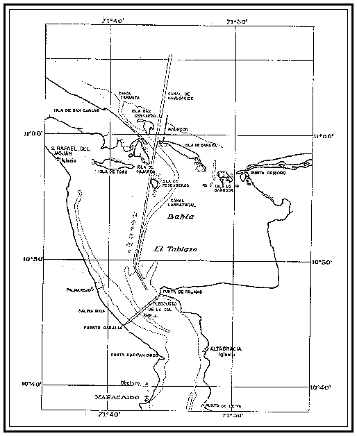
Toas Island, some 6 kms. long and 1½ kms. wide, is situated in
Tablazo Bay, the northern extension of Lake Maracaibo, about
35kms. to the north of the city of Maracaibo. As soon as the
launches leave the dock and get out into the ship channel, the
island may be seen on a clear day in rudged profile againts the
northern horizon. It constitutes the only high land in the
islands or along the stores of Tablazo Bay. The Spanish word
toas means tow ropes.
Politically, Toas Island forms part of the District of Mara. The
largest village on the island is El Toro, situated along the
store of a small bay on the north coast. At the time of the 1950
census, its population was 688. The inhabitants of Toas Island
are mostly fishermen and quarrymen. The economical importance of
Toas lies in the fact that its Cretaceous limestone is the
nearest source of easily exploitable raw material for the cement
and construction industries of the State of Zulia. With the
cement manufacturated from the limestone of Toas the oil
industry cement casing, plugs back and plugs for abandonment,
manufactures the concrete piles and caissons that support the
derricks that dor the lake, and constructs the docks, offices,
shops, schools, hospitals and homes for its workers. The housing
and road construction industries of all of Zulia employ the
limestone of Toas in the forms of both cement and gravel. The
great jetty which helps to keep the 37-foot dredged channel
across the Lake Maracaibo bar from filling up with sand
transported by the longshore currents was built with blocks of
limestone from Toas. The new bridge over the narrows connecting
Lake Maracaibo with Tablazo Bay will require 206,000 cubic
meters of concrete made of limestone from Toas, and the causeway
at its eastern end in constructed of blocks of the same
material. This large and ever-increasing consumption of Toas
Island limestone threatens the gradual destruction of the most
imposing part of a geogically unique natural monument.
Large scale quarrying operations began only some twenty years
ago, but already the topography of the southwestquarter of the
island has been greatly altered, as reference to the maps of ten
or twenty years age will readily demonstrate.
As the launches approach the sout coast of Toas Island, most of
the large quarries will become visible. They are situated in an
eastwest trending belt of light gray brownish gray, massive,
thick-bedded limestone belonging to the Apón formation of the
Cogollo group. Identification of the following fossils indicates
a Lower Cretaceous (upper Aptian) age and a shallow-water marine
environment.
Foraminifera:
Orbitolina texana (Roemer), lower Aptian to middle Albian
Quinqueloculina sp.
Spiroloculina sp.
Triloculina sp.
Pelecypoda (or Lamellibranchia):
Amphitriscoelus waringi Harris and Hodson, Aptian
Exogyra boussingaultii d'Orbigny, Hauterivian to Aptian
Ostrea spp.
Requienia sp., fragment
Ammonoidea:
Cheloniceras sp., Aptian
Parahoplites sp., upper Aptian
Most of the Albian portion of the Cogollo group appears to be
missing at the fault contact with the Eocene, although Rod found
a thin sliver of beds containing the microfauna of the Albian
Lisure formation north of that contact at the southeast end of
Cerro Caribe. The zone of Choffatella decipiens Schlumberger,
which occurs in the Tibú member of the Apón formation at the
base of the Cogollo in the Sierra de Perijá, has not yet been
encountered on Toas Island and may never have been deposited.
The bulk of the Cogollo of Toas Island seems to be
paleontologically correlative which the middle member of the
Apón formation of our previous field trip to the Río Negro
section.
At Punta Arena (Punta La Salinita) on the west end of the island
is the quarry which used to belong to the Caribbean Petroleum
Company, now Compañía Shell de Venezuela. In 1942-43, this was
an excelent locality for collecting Orbitolina texana (Roemer),
but subsequent excavation has completely eliminated these large
foraminifera. The quarry is now owned and operated by the
Martin Engineering Company. Half a kilometer to the east lies
the quarry of the Raymond Concrete Pile Company. Seven hundred
meters farther east is a second quarry of the Martin Engineering
Company at Los Buchones. Another 1200 meters eastward the
quarries of the Compañía Anónima Venezolana de Cementos may be
observed at and east of Taparo. They formerly were the property
of Juan E. París.
The hills formed by the Apón limestone in the southwest part of
the island are the highest in all of Toas. From west to east
they are named Cerro Caribe (originally 50 m.), Cerro Guano (50
m.), Cerro Buchones (100 m.), Cerro Picacho (80 m.), Cerro Vigía
(110 m.) and Cerro El Hato (50 m.). On the top of Cerro Vigía,
the highest point on Toas Island, stand the twin towers of the
station that relays television programs from Caracas to
Maracaibo.
8:30 A.M. The launches will tie up to the dock of the Compañía Anónima
Venezolana de Cementos at Taparo on the south coast of Toas
Island and the party will go ashore. The taparo (Crescentia
cucurbitina) is a tree with yellow flowers and fruit three
inches long having hard brittle hulls used as containers.
Crescentia cujete, the calabash tree, is a near relative. Walk
by the office building of the quarry on its eastern side and
Stop 1 follow the small path which leads in a northwesterly direction
to the quarry where the Eocene shales are exploited as one of
the raw materials for the manufacture of cement. The Eocene
section consists here mainly of gray blue and greenish shales
with thin bands of intercalated sandstones. The shales often
contain concretions of iron oxides, some carbonaceous matter and
folia of selenite. Black shales are less abundant. The Eocene
shales are in fault contact with limestones of the Cogollo
group. Looking eastward towards the opposite side of the quarry,
one can see the fault surface on the Apón limestone. The
striations on the fault surface are horizontal or subhorizontal
and indicate the transcurrent character of this
northwest-southeast trending fault. The northern limit of the
Eocene complex is also bounded by a fault, one which trends
approximately east and west. The Eocene shales dip steeply
northward in contrast to more gently southward of southwestward
dipping Cretaceous beds of the southern flank of the Toas
structure. The Eocene sequence is not overturned, since the
succession of microfloras is normal rather than reversed. Both
Creole and Atlantic correlate this predominantly shale section
with some part of the Eocene Mostrencos formation. Before the
Compañía de Cementos began its operations here, Taparo was the
site of a local pottery and brickyard with several kilns and a
small quarry in the Eocene shales east of Taparo. The shales in
this artea have been entirely stripped off and the underlying
Cogollo limestones are now being quarried.
9:00 A.M. Return to dock and board the launches, which will run westward
along the south shore of the island past the other three
previously mentioned quarries, and, rounding Punta Arenas, the
western termination of Toas Island, will head for the dock of
the quarry operated by the Instituto Nacional de Canalizaciones
and situated only three hundred meters west of the little
fishing village of Carrizal. Half way between Punta Arenas and
the dock, on what was formerly the northeast slope of Cerro
Caribe, is the locality from which the ammonites Cheloniceras
and Parahoplites were obtained. This locality has also been
destroyed by the ancroachment of the quarries.
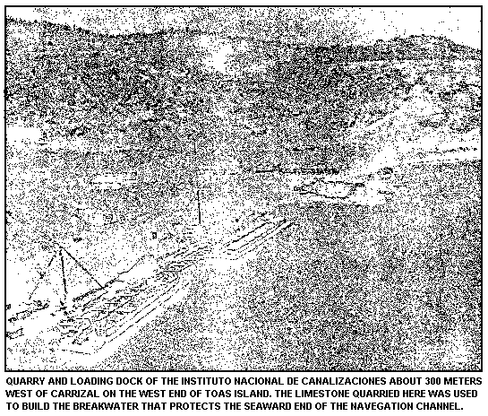
9:30 A.M. The launches will tie up to the dock of the Instituto Nacional
de Canalizaciones and the party will land. Lunches will be left
aboard. As soon as the party goes ashore, the launches will
continue their way around the north side of the island to the
public dock at El Toro. The field trip party will walk the 300
meters to Carrizal and another 300 meters beyond it along the
road to El Toro. Here the road swings to the left and a good
outcrop of basement granite can be seen just off the road on the
right.
This walk will provide the first opportunity to observe the
vegatation of Toas Island, which is typical of the arid areas
along the Caribbean coast of Venezuela. The scanty xerophytic
flora consists almost entirely of the prickly pear cactus or
tuna (Opuntia caracasana), the organ cactus or cardón
(Lemaireocereus griseus) and the thorn tree or cují (Prosopis
juliflora). A few coconut palms (Cocos nucifera) groe along the
shore.
Along the Toas beaches the most abundant shell by far is that of
the brackish-water pelecypod Cyrena arctata Deshayes, a species
that was originally described from Lake Maracaibo and may
perhaps be restricted to it. A few shells of the mangrove oyster
Crassostrea rhizophorae (Guilding) and the green mussel Mytilus
viridis Linné can occasionally be found, but the shells of the
gastropods Purpura patula (Linné) and Thais (Thaisella) coronata
(Lamarck) are quite rare. Barnacles are frequently seen attached
to rocks at the shore line.
9:45 A.M. Stop at granite basement. The stratigraphically lowest and
Stop 2 apparently the oldest formation on Toas Island is a massive,
rather coarse-grained granite. When fresh, it looks pink because
of the orthoclase, and it is dotted with dark crystals of
biotite in the form of thick bundles of mica flakes. On
weathering, which it does rather readily, the granite changes in
color from pink to gray and the biotite becomes a golden brown.
The rock becomes soft and crumbly and is easily eroded. For this
reason the granite core of the western half of Toas Island
forms a topographically low flat valley between ridges of Apón
limestone. In the smaller eastern part of the island, which is
joined to the western part by Recent beach sands and lagoonal
deposits at and south of El Toro, the granite has been intruded
by dikes of rhyolite, which are generally more resistant to
erosion and form the cores of low hills, the highest of which,
Cerro La Cruz, rises about 50 meters above the level of the
lake. Half way between El Toro and Cardón is an area where basic
rocks have intruded the granite and have in turn been intruded
by rhyolite dikes.
The contact between the granite basement and the overlying La
Quinta formation is usually hidden by talus but is almost
certainly an erosional one. No contact metamorphism and no
apophyses of the granite in the La Quinta have ever been
observed. Pebbles, cobbles and even small boulders of a biotite
granite similar in composition to that of the basement occur in
conglomerate bed of the La Quinta on the north side of the
island in the saddle between Cerro Blanco and Cerro Corozal.
Stop 3 Return along the road to Carrizal, where a fairly good section
of the La Quinta formation can be studied in the gullies south
of the village (see sketch). A mass of dark violet to brownish
red, weathered rocks lies at the base of the La Quinta section
in the gully above the masonry culvert and to the east of the
gully. Thin sections of specimens collected from this locality
indicate that at least part of this body consists of pyroclastic
rocks. Tuffs of intermediate composition (probably dacitic to
andesitic) have been determined by Shell petrographers. About 10
meters of whitish to greenish coarse arkosic sandstones
internedded with brownish red silty shales weathering to clays
follow the pyroclastics after a short covered interval. A second
short covered interval separates this 10-meter sequence that is
quite similar except that the sandstones are pink and may
include a few small pebbles. A bed dark violet red rock about 40
centimeters thick, probably tuff like similar mass below, caps
the second sandstone and shale sequence.
This bed is overlain by 8 meters of brownish red shale that is
weathered to clay, in interbedded with a few thin sandstones and
is partly covered. Several feet of whitish to greenish siltstone
and fine sandstone occur at the top of the formation. The La
Quinta of Toas Island appears to be completely unfossiliferous
and to consist probably of continental deposits. At its type
locality in Táchira the La Quinta is considered to be Upper
Triassic to Jurasic in age on the bases of stratigraphic
position and fragmentary remains of a primitive species of the
ganoid fish Lepidotus found in coprolites of some unknown
predator. Lepidotus ranges from the Upper Triassic to the Lower
Cretaceous and has been encountered in both fresh-water and
marine sediments.
The contact of the La Quinta with the overlying basal Cretaceous
Río Negro formation is unconformable. Just to the west of El
Hato on the south shore the Río Negro may be seen lying directly
on the granite basement with the La Quinta missing. In fact, the
only known La Quinta south of the granite is in the Carrizal
area. Here the base of the Río Negro is probably marked by a
stratum of coarse to conglomeratic sandstone with grains and
pebbles reworked from the La Quinta red beds. This sandstone is
exposed near the heads of the gullies. The rest of the formation
is locally covered by soil and talus, but ocassional blocks of a
fairly clean, whitish to cream-colored arkosic sandstone are
scattered about amid the more numerous and conspicuous blocks
and boulders of the more resistant Apón limestone. Croos-bedding
is not uncommon in the Río Negro. The formation is
unfosiliferous on Toas Island, as it is in most of western
Venezuela. It appears to cross time lines and to accompany the
gradual transgression of the Cretaceous seas. It is believed
that Toas Island was in a topographically high area at the
beginning of the Cretaceous and that consequently the Río Negro
is here not only much thinner but also considerably tounger than
at its type locality in the Machiques trough.
The basal Cretaceous Río Negro sandstones are overlain
conformably by the Apón limestones of the Cogollo group. At
Carrizal these limestones form the scarp at the top of the hill
south of the houses. The lowest limestones are platy and
interbedded with sandstones and a few dolomitic layers.
Shallow-water marine pelecypods, incluiding the genera Ostrea
and Exogyra, are visible in cross sections but are difficult to
extract, and specimens well enough preserved for specific
identification have not yet been found. This basal sequence is
overlain by dense to microcystalline, gray to brownish gray,
thick-bedded limestone with sometimes a few thin intercalations
of gray shale or yellowish brown marl. Nowhere on Toas Island
has a complete section of the Apón been discovered. The maximum
thickness of the portion preserved is about 75 meters in the
southern ridge and much less than that in the northern ridge,
because faults have out so much of the normal section. The
fossilspreviously listed indicate that at least part of the
section is upper Aptian in age and correlative with the middle
Apón of the type section. Howhever, between the locality where
the diagnostic upper Aptian ammonites were found and the
conformable base of the formation there should be room for some
lower Aptian beds.
At Carrizal and elsewhere along the north slope of the southern
ridge the dips average about 25° and vary from south to
southwest in the Mesozoic sedimentary section. On the south
slope the dips range from a maximum of about 62° at the west end
of the island to a minimum of 20° near Manzanillo. Most
geologists now seem to agree that Toas Island should be regarded
as an elongated upthrown fault block or wedge which, at least
superficially, was compressed to from an anticlinal structure.
The section at Carrizal in on south flank of the deeply eroded
anticline. In addition to the east-west major faults that bound
the Toas block to the north and south, there are many minor
cross faults. On the southern limb of the anticline most of
these cross faults trend northwest and southeast. In the
subsidiary blocks thus formed, the dips may be south,
south-southwest or southwest. In the block south of Carrizal the
dip is to the southwest.
10:30 A.M. Walk from Carrizal across the alluvial plain, which occupies
the center of the valley eroded in the granite, to Cerro Blanco,
a hill 50 meters high, which forms the west end of the northern
ridge. Because of a read-bordered marshy inlet it is impossible
to follow the shore by the most direct route. Incidentally, the
name Carrizal is a Spanish word meaning an area where reeds
grow. A short detour inland must be made, following at first the
road from Carrizal to El Toro for almost a kilometer. Then cross
the dry wash and turn black westward to the coast at the
southwestern slope of Cerro Blanco. As you near the coast, you
will see outcrops of the La Quinta red beds on your right.
11:00 A.M. The southern and eastern slopes of Cerro Blanco display good
Stop 4 outcrops of the La quinta red beds. At the bottom of the
southwest slope the dark red shales contain dikes of purple
diabase basalt composed 50% of the feldspar labradorite, 35%
of the pyroxene augite and 15% of magnetite, according to a
petrographic study for Creole by José Más Vall. The term diabase
basalt is used for rocks that look like basalt to the naked eye
but reveal diabasic texture in thin section under the
petrographic microscope. These dikes are cut by small veins if
granite pegmatite composed of moderately large grains of white
quartz and pink orthoclase. Still later, joints were formed and
the fissures were filled by calcite or by clay, principally the
latter. More diabase basalt dikes may be observed at the foot of
the west slope of the hill behind the houses that occupy the
narrow strip of shore. There the pegmatite veins are absent.
On the west slope of Cerro Blanco, the Río Negro basal
Cretaceous sandstone is found in contact with the intruded La
Quinta red beds and with the Cogollo limestones. Dips in the
Cogollo range from 25 to 55 degrees tp the southwest and average
about 45 degrees. It will be noted that Shell has mapped the
Cretaceous at Cerro Blanco as a faulted normal sequence, while
Creole has mapped the same beds as a faulted overturned
sequence. Rod (1956, Bull. Amer. Assoc. Petrol. Geol., vol. 40,
n° 3, p. 463, fig. 3) also has interpreted the section on Cerro
Blanco as overturned but has located his faults quite
differently. If the sequence on Cerro Blanco is normal, then the
boundary between the Cretaceous and the La Quinta to the south
is a fault contact, but, if the Cretaceous formations and
overturned, the usual unconformable relationship between the La
Quinta and overlying Río Negro should occur.
11:30 A.M. Proceed to the summit of Cerro Blanco for a view of an
Stop 5 interesting panorama. To the west acroos the northwest angle of
Tablazo Bay lie the houses of San Rafael del Moján, often called
San Rafael or El Moján for short. This town of 3,347 people,
according to the census of 1950, is the capital of the District
of Mara. Moján is an Indian word meaning witch doctor or shaman
and was probably the original name of the village before the
Spaniards arrived. The Spaniards renamed it San Rafael and the
two names heve been combined according to custom in ordeer to
distinguish this particular San Rafael from others of the same
name. As mentioned before, launches, running about once an hour
during the daytime, ferry passengers back and forth between San
Rafael del Moján and El Toro, the principal village of Toas
Island. Punta Reina is the name of the headland 3 kilometers
southeast of El Moján, and 4 kilometers northwest of El Moján
Punta Cabecita can be seen at the mouth of the Río LImón. The
Limón is a large river formed by the conjunction of the Río
Socuy and the Río Guasare about two kilometers west of
Carrasquero. It is the boundary between the District of Mara and
the District of Páez throughout its length. From its mouth the
boundary turns north up the Caño Paijana, which separates the
island of San Carlos from the mainland.
On the horizon behind El Moján, The Montes de Oca, which form
the northern end of the Sierra de Perijá, are visible on a clear
day. The Montes de Oca rise to an altitude of about 3,500 feet
and continue the northeasterly trend of the somewhat higher
Serranía de Valledupar, from which they are separated by a
distint saddle. They extend for a length of about 50 kms. to the
northeast and then at a second saddle swing eastward for another
25 kms. The eastward swing, called the Fila de Majuyura, was
explained by John B. Miller in a paper given last year before
the Third Venezuelam Geological Congress (see his fig. 13) as an
anticlinal horst whitin a fault zone, the main fault extending
in an east-west direction and bounding the horst on the north.
The similarity of this structure to the one at Toas Island seems
apparent.
Both the fault zone and the main fault are generally known as
the Oca fault, misspelled "Ocoa" by the originator of the name,
F. A. Sutton (1946, Bull. Amer. Assoc. Petrol. Geol., vol. 30,
n° 10, p. 1718-1719), and by Rod (1956, loc. cit., p. 459-463),
first correctly spelled by W. H. Bucher (1952, Geol. Soc. Amer.,
Mem. 49, p. 8). A synontm of the name Oca fault is the name Páez
fault zone, first published by J. E. Smith (1951, Third World
Petroleum Congress, Section 1, The Hague, p. 64, figs. 1, 2).
Dufour(1957, Geol. Rundschau, vol. 45, n° 3, p. 765) called it
"the Páez or Oca fault". In order to clarify the confusing
terminology and rendeer it more precise we propose that the
junior synonyms Páez fault zone and Páez fault, and the
erroneous spelling Ocoa fault be suppressed, that the name Oca
fault be restricted to the major fault which runs along the
northern foot of the Montes de Oca near the Venezuelan-Colombian
boundary and that this name be retained only as far as the
direct continuation of this specific fault can be ascertained.
Faults which run parallel or subparallel to this fault should be
given different names, but, together with the Oca fault, they
may be grouped under the term Oca fault zone. This latter term
should be restricted to only those faults not more than ten
kilometers apart from the Oca fault on either side.
From its type locality at the Montes de Oca fault zone extends
westward across the bassed of the Guajira Península to the
Caribbean coast of Colombia, along which it may continue
westward, forming the northern boundary of the triangular Santa
Marta massif. From the Montes de Oca the Oca fault zone extends
east-southeast to the Río Limón about seven kilometers north of
Carrasquero, according to Rod's Figure 2, and continues in this
direction through the Laguna de Sinamaica to the mouth of the
Río Limón. The river does not follow the fault zone but winds
back and forth across it and then empties into Tablazo Bay.
The published literature shows differences in opinion on the
course of the Oca fault between the Laguna de Sinamaica and the
mouth of the Río Limón. Smith (1951, loc. cit., figs. 1, 2)
depicts his "Páez fault zone" as only about a kilometer in width
and situated midway between El M has hisoján and the south bank
of the Limón. Rod (1956, loc. cit., p. 459, fig. 2) has his
"Ocoa fault" drawn as a fault zone about two kilometers wide
with its north edge at the north bank of the mouth of the Limón
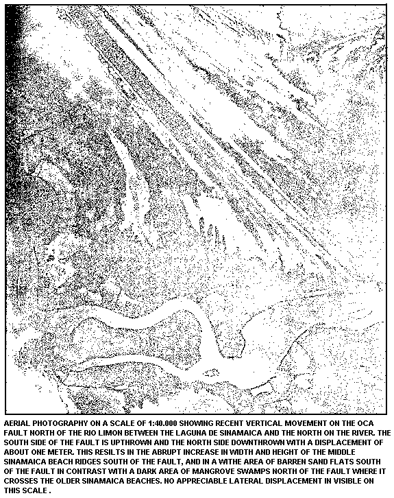
and its south edge a kilometer south of the south bank. An air
photograph of the area clearly indicates recent vertical
movement along a fault running east-southeast across the
Pleistocene Sinamaica beaches and disappearing in the mangrove
swamps more than a kilometer north of the mouth of the Río
Limón. It is this fault which Miller (Fig. 14) has termed the
Oca fault, and he also shows a somewhat more dubious unnamed
fault subparallel to the Oca fault about a kilometer to the
south between the Oca fault and the north bank of the Limón. The
current consensus of informed opinion is that Miller has
correctly picked the true Oca fault and that Smith's "Páez fault
zone" locally consists of a single subparallel fault distinst
from the Oca fault itself but part of the Oca fault zone. The
Shell geologists have renamed this fault the north Moján fault.
The question that at once comes to mind is what relationship
these mainland faults may have with those on Toas Island. It is
interesting to note what happens when the traces of the mainland
faults, as published in the literature, are prolonged eastward
whiout deviation fron their known courses. The true Oca fault
prolongation would approximately follow the southern shore of
San Carlos Island and the North Moján fault prolongation would
tie into the east-west faults on the north side of Toas Island.
It thus appears quite probable that, although the Toas Island
block undoubtedly forms part of the Oca fault zone, the main Oca
fault may pass wel to the north of it.
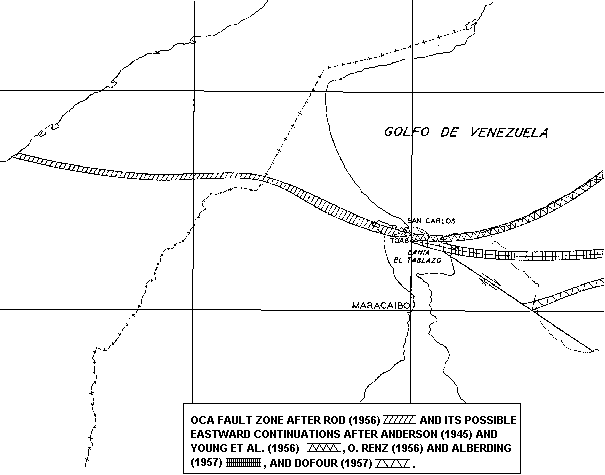
What becomes of the Oca fault zone east of Toas Island is a
question that has elicited many diverse answers. J. L. Anderson
(1945, Bull. Amer. Assoc. Petrol. Geol., vol. 29, n° 8, p. 1079,
fig. 8) and Young, Bellizzia, H. Renz, F. Johnson, Robie and Más
Vall (1956, Bol. Geol., Pub. Esp. 2, Ministerio de Minas e
Hidrocarburos, Caracas, p. 21-28, figs. 6-12) agree in
continuing the fault zone northeastward along the rather
straight coast of Falcón. According to the latter publication,
movement along the main Oca fault zone began in the Paleocene,
but movement alongs its continuation on the shore of Falcón did
not begin until the orogenesis at the end of the Eocene. No
evidence is provided to substantiate these hypotheses. Sutton
(1946, loc. cit., p. 1718, fig. 7) also continues the "Ocoa"
fault zone eastward along the coast, but only for a short
distance to the Zulia-Falcón boundary, where he ends it abruptly
for no stated reason. Miller, Edwards, Wolcott, Anisgard,
Martin and Anderegg (1958, Habitat of Oil, Amer. Assoc. Petrol.
Geol., symposium, p. 613, 615) swing the eastward continuation
of the Oca fault zone somewhat south of the coast line
approximately in the vicinity of the village of Quisiro and,
like Sutton, end it abruptly at the Zulia-Falcón boundary (Fig.
6). However, on page 615 they state: "Eastward, the fault belt
probably merges with the north limb of the Falcón structural
uplift". O. Renz (1956, "Cretaceous in western Venezuela and the
Guajira (Colombia)", Proc. 20th Internat. Geol. Cong., Mexico
City, fig. 3) and Alberding (1957, Bull. Geol. Soc. Amer., vol.
68, p. 790, pl. 1) both show an inferred continuation of the Oca
fault zone extending almost due east half way across the State
of Falcón. Rod (1956, loc. cit., p. 459, fig. 2) terminates the
"Ocoa" fault zone abruptly with a pair of question marks
inmediately east of Toas Island. On p. 462-463 he asserts: "East
of Toas Island the Ocoa fault loses its individuatily and is
resolved in several en échelon faults, the eastward continuation
of which is not clear. A branch fault very likely crosses the
folded mountains of Falcón and is again replaced farther east by
the stike-slip fault system of the Caribbean Mountains".
Dufour(1957, loc. cit., p. 761, fig. 1; p. 771, fig. 4)
indicates a southeastward offset of the Oca fault zone by a
single cross fault, with his fig. 4 showing a greater distance
of offset than his fig. 1. Although he makes no mention of it,
the fault zone bounded by the El Mene de Mauroa fault on the
south and the La Cumbre fault on the north falls within the
range between his two figures, and he may have intended to
propose the theory that the El Mene de Mauroa fault is the
dislocated continuation of the Oca fault. On the other hand,
Alberding and Young (1958, Asoc. Venezolana Geol. Min. Pet.,
Bol. Inform., Caracas, vol. 1, n° 1, p. 13, fig. 17) postulate a
N. 30° W. dislocation which would offset the Oca fault an
unspecified distance by means of two parallel cross faults and
place its eastward continuation somewhere in the Gulf of
Venezuela.
It seems obvious that there has been both vertical and
longitudinal displacement along the Oca fault zone. The upthrust
of the Toas Island block is evident. At the north end of the
Montes de Oca it seems clear that the south side of the Oca
fault is upthrown and the north side relatively downthrown. The
eastward curvature of the Tigre fault and of the anticlinal axes
in the eastern foothills of the Montes de Oca as they approach
the Oca fault zone (Rod, 1956, fig. 2) can best be explained as
drag resulting from right lateral displacement along the type of
fault variously known as strike-slip, transcurrent or wrench.
Dofour (1957, p. 765) suggests that this displacement may be of
the order of 90 kilometers on the heory that the Central
Cordillera, the Santa Marta block and the Guajira Península
originally formed a single elongate massif. However, oven if
this theory were correct, it is not necessary to assume that the
entire displacement "of 90 kilometers" took place along the Oca}
fault zone. The authors believe that the Oca fault zone includes
only a few of the subparallel, potentially transcurrent,
east-west faults in the region between the Guajira massif and
the Maracaibo platform, and that the total theoretical lateral
displacement should be shared among all or most of these many
different faults.
Miller has recently described the latest movement at true Oca
fault between the Laguna de Sinamaica and the mouth of the Río
Limón in southeastern Distrito Páez. Here the fault runs
east-southeast, cutting through Quaternary beach deposits termed
the older, middle and younger Sinamaica beaches. Still younger
beach deposits called the San Carlos beaches lie to the
northeast along the shore of the Gulf of Venezuela. The trace of
the fault can be clearly seen in an air photograph, crossing the
older and middle Sinamaica beaches, but the younger Sinamaica
beaches mostly disappear beneath the mangrove swamps on the
north bank of the Limón, and the fault trace is thus almost
entirely concealed. The north side has been downthrown at least
one meter where the fault crosses the middle Sinamaica beaches,
with the result that the beach ridges increase both in width and
height inmediately scuth of the fault. Where the fault crosses
the older Sinamaica beaches, a large area of saand flats south
of the faults contrasts with an area of mangrove swamp north of
it. According to Miller, there is no lateral displacement
visible, but it is unlikely that a small lateral displacement
would show up distinctly on the air photograph, which is on the
scale of 1:40.000.
Looking from Cerro Blanco toward the northwest and north, one
sees San Carlos Island across the waters of the northwestern
part of Tablazo Bay. This island is separated from the mainland
of the Sinamaica area by a narrow natural channel, the Caño
Paijana, which, as previously mentioned, forms the boundary
between Distrito Páez on the mainland and Distrito Mara on San
Carlos. Because the Caño Paijana is so narrow, the island of San
Carlos somewhat resembles a península extending to the southeast
and separating the waters of the west half of Tablazo Bay from
those of the Gulf of Venezuela. There are no roads or bridges
across the swamp-bordered Caño Paijana and all transport to and
from San Carlos Island is by boat.
The Quaternary deposits which cover the flat terrane around the
towns of El Moján and Sinamaica and on San Carlos Island
consists mainly of a series of beach deposits. The older of
these beaches have been called the Sinamaica beaches by Miller
and are presumably Pleistocene in age. On aerial photographs a
great number of parallel to subparallel, rather narrow, linear
beach ridges can be observed in the vicinity of the town
Sinamaica, all of them striking in an approximately
northwest-souteast direction. The middle ridges are by far the
most prominent, while the older island and tounger seaward
ridges are not so prominent and are separated by wide areas of
sand flats. This has caused Miller to classify them as the
older, middle and younger Sinamaica beaches. Some eight to ten
kilometers southeast of Sinamaica these beach ridges are
interrupted by the broad mangrove swamps that border both banks
of the Río Limón near its mouth. Their sotheasterly continuation
is encountered in the vicinity of El Moján, which is situated
amid the younger Sinamaica beaches. The Sinamaica beach ridges
are the traces of former shore lines and were formed one after
another by seaward accretion to the land area. They may have
originated as barrier islands separated from the mainland to the
southwest by lagoons, which were later almost completely filled
up by the delta deposits of the Río Limón. The large quantities
of sand which were deposited in all of these Quaternary beaches
were transported by means of longshore currents flowing
north-wesward.
The younger Quaternary beach deposits, probably Holocene in age,
are quite well developed on San Carlos Island and cover yhe
northern two-third of it. For this reason they have been named
the San Carlos beaches Miller. They continue in a slightly
narrower belt along the mainland coast northwestward past
Sinamaica. Strangely enough, the younger San Carlos beaches are
not as well preserved as the older Sinamaica beaches. On the
east end of San Carlos Island these younger beach ridges have
been truncated by marine erosion. Everywhere on the siland they
are in the process of destruction by wind erodion and of
obliteration by linear sand dunes, which are oriented parallel
to the direction of the prevailing northeast trade winds. The
Sinamaica beach ridges, partly covered by vegetation and located
farther back from the exposed coast, are very much less affected
by the trade winds, most of the erosion being recent and
confined to the younger Sinamaica beaches, where is the least
vegetation cover. One possible explanation might be that the
trade-wind climatic zone lay farther to the south during the
Pleistocene glaciation and the deposition of the Sinamaica beach
ridges, and that it did not move north to its present position
until post-glacial time and the period of the deposition of the
San Carlos beach ridges. The southern third of San Carlos Island
consists of dense mangrove swamps, plainly seen from Cerro
Blanco. The Castillo and village of San Carlos lie together on
the eastern tip of the island, hidden from the observer on Cerro
Blanco by another much smaller mangrove-covered island variously
known as the Isla del Diablo or the Isla de Pájaros. This
smaller island is separated from San Carlos by a channel that is
navigable to small boats, although quite narrow, and is called
the Caño San Carlos.
From Cerro Blanco to the east extends the strongly faulted
northern flank of the Toas structure. On the eastern horizon the
sand dunes of Zapara Island may be recognized. To the southeast
and south lie the limestone hills of the south flank of Toas
structure, topped at their highest point by the television relay
station. The steep scarp slope is in full view across the deeply
weathered granite of the axial topographic depression. With the
exception of the Carrizal area, the rocks of the La Quinta
formation are missing along the southern flank of the Toas
Island structure, so that the Río Negro formation overlies
unconformably the granitic core of the island.
12:00 M.    Proceed down the eastern slope of Cerro Blanco to the
Stop 6      topographical saddle between Cerro Blanco and Cerro Corozal,
            the next hill to the east in the northern range. According to
            Shell's interpretation, a thin zone of Río Negro formation
            occurs between Cerro Blanco and the saddle. On Creole's map the
            Cogollo group is in fault contact with La Quinta formation.
            At the slope between the saddle and the lake shore to the north
            of it, an interesting section of La Quinta formation some 25-30
            meters thick can be studied. As this locality the La Quinta
            section is composed mainly of olive green and rusty red,
            weathered, coarse and gritty arkosic sandstones, brown red silty
            clays and several intercalations of thick conglomerate beds. The
            pebbles of the conglomerates sometimes exceed 10 centimeters in
            diameter and consist of granites, porphyritic and/or pyroclastic
            rocks, quartzes and, occasionally, limestones. According to O.
            Renz (oral information), fusulinids have been found in a few of
            the limestone pebbles. This information indicates that the
            pebbles were probably produced by the erosion of limestones in
            the Permian Palmarito formation, which is not exposed on Toas
            Island. The stratigraphic position of this succession whitin the
            La Quinta formation is uncertain, since it was not found at
            Carrizal and because the section may be in fault contact with
            the Cretaceous.
12:30 P.M. Go eastward on path which follows the shore line. Between La
Conserva and El Corozal the cliffs to the south of the path
consist of strongly broken limestones of the Cogollo group. In
this area the northern flank of the Toas structure appears to be
overturned and local imbrication adds to its structural
complexity. Impregnations of residual oil are reported to occur
at some places in fractured limestones.
Stop 7 At El Corozal the slope of the hill is composed of dark grey
shales at least 15 meters in thickness. These shales contain
assemblages of upper Senonian small foraminifera and are,
therefore, considered to correspond with parts of the Colón or
La Paz shales of the Mara-Maracaibo area.
Stop 8 Just before reaching the houses of Las Playitas, at the rocky
point where the shoreline bends towards the sotheast, these is a
small outcrop of Guasare formation. This is the type locality of
the Toas limestone, an obsolete junior synonym of the Guasare
formation. From the shore to some ten meters higher up,
alternating beds of impure, olive green, soft, glauconitic
sandstones, of sandy shales and of thick-bedded, light brown and
partly glauconitic Ostrea and Venericardia limestones occur. The
Paleocene age of these rocks was mainly determined on the basis
of the lamellibranch species Ostrea buski Woods and Venericardia
(Venericor) toasensis Dusenbury. The first species occurs in the
Paleocene Negritos formation of Perú. The second is
characteristic of the basal limestone development of the Guasare
formation in other parts of western Venezuela where undisturbed
sections are present, e.g., in the Río Cachirí and the Caño Frío
in western Mara or in the Monay Basin near Casa del Zinc in
northeastern Trujillo. The Paleocene age of this interval is
corroborated by the finding of diagnostic small foraminifera in
some of the thin weathered layers at the surface of the sandy
limestones. See Sutton, 1946, p. 19659, for the complete faunal
list.
A narrow belt of black carbonaceous shales, which locally
contain thin sandstones and coal layers, extends along the coast
from Las Playitas towards the east in fault contact with the
Cogollo limestones to the south. In earlier days coal was
exploited from these beds and used to fire the local lime kilns.
The Paleocene age of these coal layers was recently established
on pollen evidence. Lithologically, the section can be compared
with part of the Marcelina formation (an equivalent of the lower
part of the Paso Diablo formation) of the Río Guasare area.
1:00 P.M. Arrive at Las Playitas. Lunch will be eaten in the shade of the
palm trees. Lunches, beer and soft drinks will be brought from
the launches at El Toro by taxi and distributed.
2:00 P.M. Proceed southeastward to the road which leads to El Toro,
follow the road eastwards to El Toro to embark on launches.
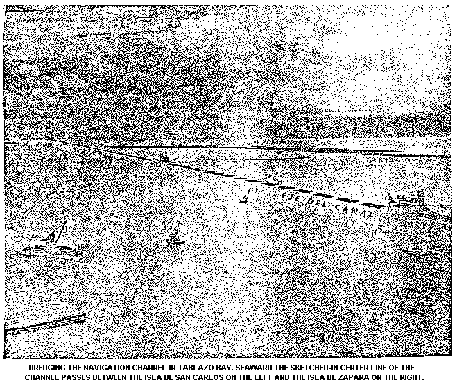
2:30 P.M. The launches depart from El Toro, proceed directly nirtheast
across Tablazo Bay to the Caño San Carlos and enter this narrow
channel between the Isla de San Carlos on the left and the Isla
de Pájaros on the right. The barges carrying the limestone
blocks from the quarries on the west end of Toas Island for the
construction of the breakwater to protect the channel across the
Lake Maracaibo bar were towed to their destination through the
Caño San Carlos. After navigating the length of the Caño, the
launches arrive at the village and fort of San Carlos.
3:00 P.M. The party will go ashore at the Castillo de San Carlos.
Stop 9 Permission to do this and the services of a guide were obtained
through the courtesy of the Instituto Nacional de
Canalizaciones. The village of San Carlos is inhabited
principally by fishermen and had a popullation of 667 in 1950.
The Castillo next to it was originally built to protect the
entrance to Lake Maracaibo against pirate raids but has been
used as a prison since colonial days. It was particularly
infamous for the detention and torture od political prisoners
under the dictatorship of Juan Vicente Gómez from 1908 to 1935.
Eustóquio Gómez, the dictator's brother by adoption and a
convicted murderer, was realesed from prison, when Juan Vicente
Gómez seized power, and was placed in charge of the Castillo de
San Carlos during 1909 and early 1910. In May, 1910, there was
an uprising of the prison guards and employees against
Eustóquio's greed and mismanagement. Warned in time, Eustóquio
escaped in a fisherman's boat. Juan Vicente was quite amused by
the affair and promoted Eustoquio to the governorship of the
State of Táchira.
When the General Gómez died and his regime came to an end in
1935, the prisoners were released and the Castillo was
abandoned. In recent years it has been employed as a storage
place for explosives.
Across the entrance to Lake Maracaibo lies a string of shoals
and barriers islands which, together with the shallow depths of
Tablazo Bay, is known generally as "The Maracaibo Bar". The name
"Outer Bar" has traditionally been applied to the section of
shifting sand banks immediately north of the Isla de San Carlos
which was crossed by the original ship channel, known as the
Canal Zaparita.
Sampling in the region of the Outer Bar has indicated that this
formation consists almost entirely of fine sand, apparently of
marine origin and probably transported westward from off the
coast of Falcón by longshore currents. Clays and silts occur in
significant proportions in the sediments of Tablazo Bay and also
further offshore in the Gulf, but apparently have been
selectively removed from the material accumulated in the Outer
Bay by the action of waves and currents. San Carlos and Zapara
Islands are characterized by spectacular sand dunes ranging in
height up to 100 feet. Mangroves cover the low-lying shoreline
along the south side of San Carlos, most of Pájaros, the east
end of Zapara, Barbosa, and Punta Oribono. San Bernando is an
artificial island formed of the material dredged from the new
navigation channel.
Zapara Island provides an interesting example of the migration
of sand under the influence of prevailing winds. In the east
central portion of the island there are two rows of cuspate
dunes, technically known as barchans, that are oriented parallel
to each other and normal to the mean direction of the wind. When
the northeast trade wind is blowing, continual tiny sand slides
can be seen on the leeward slopes. These start as a few grains,
break away from the cusp and "flow" in a steadily widening
stream of sand to the bottom of the dune. the ripples on the
windward and upper surfaces present an endless variety of
patterns apparently associated with the texture of the sand, its
moisture content, and the local configuration of the dune.
Between the two rows is a depression about 100-150 meters wide,
which is lined with ridges running parallel to the rows of
dunes.
These ridges are of the order of a foot high and 15 feet apart,
and seem to have been formed in the following way (hypothesis of
J. H. Germeraad). During the rainy season this low-lying area
holds rain water, which allows vegetation, mostly grasses, to
become rooted along the bottom edges of the dunes. The windward
edge of each dune then remains as a vegetation-anchored ridge
when the rest od the sand migrates onward during the ensuing dry
season. Thus the distance between the ridges provides a
convenient measure of the distance which the dune has migrated
during any of the years represented. carrying this hypothesis a
step further, one may infer the occurrence of a cycle of dune
formation from the existence of the two rows and associated low
areas. Starting from near the south shore of the island and
walking northeast, one encounters in succession the first row of
dunes, the first set of ridges, the second row of dunes, the
second set of ridges, an finally, just above the beach of the
Gulf shore, a row of very small dunes apparently in the earliest
stage of formation. The total distance of about 3000 feet thus
seems to correspond to slightly more than two full cycles of
dune formation. At an average speed of migration of 15 feet per
year, a cycle of the order of 100 years in suggested, in which
dune formation passes from maximum through essentially zero
activity to maximum again.
The sands bars in the region of the Outer Bar have been of
particular interest in the past because of the former navigation
channel. This was the "natural" channel, scoured by the tidal
currents as they ebbed and flooded between Tablazo Bay and the
Gulf. Extending inward across the Outer Bar, it continues
southeast along the north shore of San Carlos Island into
Tablazo Bay and parallel to the south shore of San Zapara
Island, then curves in an arc around the east side of Pescaderos
Island until it is directly south of the entrance between San
Carlos and Zapara. From here it follows a course approximately
south across Tablazo Bay to a spot just west of Punta de Palmas,
where it abruptly widens and deepens. The "natural" channel
through the Outer Bar is called the Canal Zaparita, but its
continuation through Tablazo Bay is termed the Canal Larrazábal.
One of the most intersting features of the Outer Bar was the
tendency for the Bar Channel to undergo a cyclic migration. With
a period of about 20-25 years, the channel would break through
in an easterly posiiton, then move westward at a mean rate of
about 600 feet a year until it reached a position of
instability. At this point a new channel would break through,
and the old one would fill up, starting the cycle again. The
instability of the old channel may have been due to decreasing
"efficiency" as the path lengthened, with consequent decrease of
slope and hence of the average speed of flow. The following
discussion of this process and the erosion of the Gulf shore
appears in the publication "Model Study of Channel Improvements
at Outer Bar, Lake of Maracaibo, Venezuela", (Technical
Memorandum No. 106-1 of the U.S. Waterways Experiment Station,
Vicksburg, Mississippi, December 1, 1938).
"Characteristic hydrographic trends
"40. By means of all the available maps, sailing directions, and
oral and written descriptions, it is possible to trace the
general trends which are characteristic of the Outer Bar area.
These trends might be classified under two general headings;
recession of the Gulf shore and cyclic extension of the Outer
Bar.
"41. The recession of the Gulf shore is first illustrated by the
comparison of older maps. The survey of 1794 indicates a fort on
the eastern end of Isla de Zapara, whereas the 1864 survey shows
this fort as rock reef or shoal (Roca de Barbosa) some distance
from shore. Present-day maps show this Roca de Barbosa. The
reduction in size of the Isla de Barbosa from earlier maps also
is to be noted. Hence regardless of the doubtful cartography of
the earlier maps, it is evident that Isla de Zapara receded 1.6
miles during the period 1974 to date. Recent maps corroborate
the fact that erosion is taking place. The Isla de Barbosa was
surveyed in 1935 and again in 1937, and the recession of the
northern shore of this island was clearly shown by a comparison
of the two maps. Another fact which bears out htis point is the
recession of the northern shore of Isla de Zapara from 1925 to
date.
"42. The second outstanding trends is the cyclic extension of
the Outer Bar. This has its counterparts in the cyclic posiiton
and controlling depth of the Bar Channel, in the development of
the incipient Eastern Channel, and in the movement of the bed
material along the Outer Bar is unquestionably that not only the
prevailing orientation of the Outer Bar is in a like direction,
but present a measure of its rate of extension. As the Outer Bar
is moved further to the westward, and the depths in the Bar
Channel are decreased. As the Bar Channel moves westward, the
slope at ebb tide through this channel becomes less. This
decrease in slope results in a corresponding decrease in the
velocity of flow, and channel shoaling ensues. As the main
portion of the flood flow into the lake crosses the Bar between
Isla de Zapara and the Eastern Channel, the changes at the outer
end of the Outer Bar do not affect this flow, and hence the
tidal prism, the ebb flow is not particularly affected. With a
relatively constant tidal prism, the ebb flow is relatively
constant; and, therefore, as the Bar Channel becomes less
efficient, due to its decreassed slope and crosssection, more of
the ebb flow is diverted across the Bar to the eastwards, thus
developing any potential channel in that area. A point is
finally reached where sufficient ebb flow is passing over the
Bar to cause a breakout of a new channel, and the beginning of a
new cycle. The former outer end of the Outer Bar is then
releived of the greater part of the pressure of the ebb flow on
its southwest side, and, under the action of pressure of the
waves, is moved shoreward and finally becomes a part of this
shore.
            These channels were tortuous, constantly shifting, and had
            limiting depths of the order of 12 feet. The consequent problems
            for navigation led first to the improvement and maintenance of
            the natural channel, which was dredged in  stages to 22 feet,
            and finally to the dredging and maintenance of the new channel,
            which is one of the world's great canal projects. Responsability
            for this work rests with the Instituto Nacional de
            Canalizaciones.
            The breakwater (malecón) which protects the landward end of the
            outer channel can be seen extending north from the west end of
            Zapara Island. It is 3.1 kilometers long, and contains 1.190.000
            metric tons of rock which was obtained from the Cogollo
            limestone quarries at the west end of Toas Island. The outer
            channel extends 16 kilometers north from San Carlos. It is 305
            meters wide and has been dredged to a depth of 37 feet. The
            inner channel extends 22 1/2 kilometers to the north, to reach
            the 43-foot contour line in the Gulf. It will also call for
            dredging to the same depth between Icotea Point (Cabimas) and
            Punta de Palmas del Sur.
            Since the opening of the new channel in 1955, considerable
            effort has been required to maintain the depth. In the outer
            channel this due presumably to the transport of sediments by
            transverse currents associated with the tides and the net
            longshore current. The breakwater affords partial protection in
            the region of maximum wave action where the problem would be
            expected to be more serious. In Tablazo bay the tidal currents
            tends to follow a curved path fairly well delineated by the old
            channel, which was presumably fromed and maintained by the
            scouring action of the currents. A considerable amount of the
            water now follows the broad, deep, straight new channel, but
            nevertheless enough still follows the old route to cause
            considerable deposition of sediment where its path crosses or
            converges with the channel.
            One final point of interest in connection with the currents is
            associated with the existence of an antinode of the semidiurnal
            tidal component near the middle of Tablazo Bay. As a result of
            this, on a rising tide water flows into Tablazo from the Gulf
            and from the Lake simultaneously. (Superimpossed upon this
            motion is the net discgarge of the lake and also the diurnal
            tidal component, but nevertheless the effect is clearly
            noticeable). This antinode may have contributed to the
            accumulation of sediment and the shallow depths in Tablazo Bay.
            The guns of the Castillo de San Carlos have dommanded for
            centuries the shifting natural channel which used to be the sole
            navigable entrance to Lake Maracaibo. before the present fort
            was erected in the latter part of the seventeenth century,
            Maracaibo was attacked no less than six times by the biccaneers.
            The Dutch freebooter, called by the Spaniards Enrique Gerar,
            made the first attack on Maracaibo in 1614. The second attack
            was made by the Englishman, Captain William Jackson, in 1642.
            Each time, the bar was apparently defenseless. In 1666 the
            terrible French buccaneer, Jean David Nau, better known as
            Francis l'Ollonais, captured both Maracaibo and Gibraltar, now a
            village of little importance at the south end of the lake but
            then a rich and thriving town from the export of sugar and
            cacao.
            By that time a fort sixteen cannon had been constructed in order
            to defend the entrance through the bar. When the pirates landed
            to assault the fort, its commander sent a platoon to ambush
            them, but the ambush was discoverd and the platoon was
            completely wiped out. The pirates advenced to the Castillo and
            fought a three-hour battle without quarter, finally gaining
            possession, seizing eberything of value including the cannon,
            and demolishing the walls to ensure their subsequent safe
            retreat. After two months of slaughter, torture, destruction and
            looting ar Maracaibo and Gibralter, they again crossed the bar
            on their way back to Tortuga.
            Two renegade Spaniards accompanied l'Ollonais on this raid,
            Pedro el Picardo and Miguel El Vascongado. The next year, 1667,
            Miguel El Vascongado returned to take Maracaibo for the fourth
            time with a mere 40 men in three small boats. he know that the
            soldiers killed, the weapons removed and the fort destroyed by
            the previous expedition had not yet been replaced by the
            slow-moving Spanish authorities and that he could easily compel
            the city of Maracaibo to pay a ransom without opposition. A
            small ransom was collected from the wealthier citizens and the
            pirates departed.
            Meanqhile, Pedro el Picardo, the other Spaniard who had been
            with l'Ollonais, and who not only knew the environs of Maracaibo
            but spoke good English as well, had contacted the notorious
            Englsih buccaneer, Sir Henry Morgan, in Jamaica. Morgan had
            wanted to take Cartagena, the biggest prize on the Spanish main,
            but this project was soon discarded as Cartagena was too heavily
            fortified. Perhaps Pedro el Picardo had a great infuence in
            persuading Morgan to set sail for Maracaibo instead. They both
            realized that Maracaibo and Gibraltar would be easy to take due
            to the destruction by l'Ollonais a few years before. So, early
            in 1669, they set sail from Jamaica, landing for a short while
            on the island of Aruba, where they took on fresh water and goat
            meat, which they obtained from friendly Indians. Two days later
            they came upon the reconstructed Castillo at the entrance of
            Lake Maracaibo and cannonaded it all day.
            When the night fell, Morgan discovered that the Spanish troops
            had evacuated the fort, leaving behind a lighted fuse to blow it
            up. The pirates extinguished the fuse, carried-off the
            artillery, but foolishly neglected to destroy the walls. They
            then captured Maracaibo, seized about a hundred of the richest
            inhabitants, robbed, tortured and killed for three weeks, and
            then repeated the horrible routine at Gibraltar, the principal
            port at the south of the lake. Finally, ransoms were obtained
            from 250 prisoners and from the two captured cities, but, on
            preparing to depart for Jamaica, Morgan learned that the Spanish
            admiral, Don Alonso del Campo y Espinoza, had blocked the exit
            with a fleet of three large vessels of 36, 30 and 24 guns, each
            superior to any of Morgan's boat, and had reoccupied the
            Castillo. Caught in a trap, Morgan buried part of his loot,
            prepared a fire ship by equipping a merchant ship, captured at
            Gibraltar, with a dummy crew and guns and with the necessary
            combustibles, and, on April 30, 1969, sailed out in a desperate
            effort to break the blockade. The fire ship grappled with the
            admiral's flagship, was put to the torch and abandoned by its
            skeleton crew. The ruse was eminently succesful and the 36-gun
            "Magdalena" was detroyed when the flames reached its powder
            magazine. The second spanish ship fled, ran agroung near the
            Castillo, and was burned and scuttled by its own crew, which
            then sought refuge in the fort. The third Spanish ship fought
            stoutly but was badly outnumbered and had to surrender. Don
            Alonso had escaped to the Castillo and there bravely beat off
            the assault of the pirates, who lost 60 men. Morgan retired and
            after nightfall succeeded in getting past the Castillo,
            whereupon he set sail for Jamaica with the remainder of his
            loot, amounting to 250.000 pieces of eight.
            In 1678, the French pirate, Francis de Grammont, headed the
            sixth and final raid of the buccaneers against Maracaibo, which
            had by the tima recovered from the devastation wrought Morgan.
            The expedition began as an attack by the French from Haiti on
            the Dutch island of Curacao. The 18 French vessels under the
            command of the Comte d'Estrées through an error of the pilots
            ran aground on the reefs of Los Aves with the loss of 300 of the
            men and the destruction of many of the boats. Grammont collected
            the survivors of the shipwrecks, careened and repaired nine of
            the vessels, and set out with 700 men to re-supply the fleet at
            the expense of the towns of the Lake Maracaibo area. He anchored
            off San Carlos Island, landed most of his men and besieged the
            Castillo. The outnumbered garrison of only 70 men fought for two
            days but finally had to surrender and was allowed to depart
            unharmed. The artillery and small arms of the garrison were
            taken aboard, and a number of buccaneers stayed behind to hold
            the fort. Grammont and the rest of the pirates seized Maracaibo,
            Gibraltar and Trujillo one after another, the terrorized
            inhabitants fleeing before the pillagers and carrying their
            valuables with them. The pirates obtained so little that they
            left the lake and attacked Margarita, La Guaira and Puerto
            Cabello.
            The nomenclature of the islands and forts at the Maracaibo Lake
            bar has changed with time. In the preceding account, in order to
            avoid confusion, the present nomenclature has been employed.
            However, at the time of the pirate raids the present Isla de San
            Carlos was called the Isla de las Palomas and the Isla de Zapara
            was known as the Isla de las Virginias. The fort of the site of
            the present Castillo de San Carlos was termed El Castillo de la
            Barra. A high dune of Zapara was occupied by a watchhouse, hence
            the origin of the name Isla de las Vigilias.
            In the later part of the reign of Carlos II, after the last of
            the successful pirate raids, the royal command was given to
            strengthen the defenses of the Lake Maracaibo Bar. A mcuh later
            fort was erected on the site of the former Castillo de la Barra
            and was named Castillo de San Carlos after the patron saint of
            the reigning monarch. At the same time the name of the island
            was changed from Isla de las Palomas to Isla San Carlos. Two
            more forts were constructed on the Isla de Zapara on the east
            end to guard the shallow channel between the Islands of Zapara
            and Barbosa. While the Castillo de San Carlos has been occupied
            almost continuosly and kept in repair, the Castillo de Santa
            Rosa and the Castillo de Zapara were cut off from the Isla de
            Zapara by marine erosion, which has forced the abandonment of
            the forts and has leveled them to their foundations. This is the
            origin of the name Zapara, a Spanish word meaning an undermining
            of sapping process, and in the present case evidently referring
            to the marine erosion so characteristic of this island. At low
            tide the ruins of the Castillo de Santa Rosa may be observed
            about 100 yards off the west end of Zapara and those of the
            Castillo de Zapara on a shoal about 1.6 miles north of the Isla
            de Barbosa. The ruins of a more recent fort occur in the center
            of the Island of Zapara near the lighthouse.

3:30 P.M.   The excursion group will board the launches, which will leave
            the Castillo and enter the ship channel. They will then turn
            north along the channel for a short distance in order to view
            the artificial island of San Bernando on the left and the
            breakwater, projecting from the west end of the island of
            Zapara, on the right. With luck the party may see in action one
            or more of the three dredges which the Venezuelan government
            keeps in constant operation to maintain the prescribed depth and
            width of the channel. the launches will then make a 180° turn
            end reverse their so as to follow the ship channel south all the
            way back to Maracaibo.

5:15 P.M.   End of trip on arrival back at the dock of the Mene Grande Oil
             Company in Maracaibo.
¹ Por Rudolf Blaser, Cía. Shell de Venezuela, and Arthur N. Dusenbury, Jr., Creole Petroleum Corporation, Sociedad Geológica de Venezuela Occidental, Guidebook N° 2, 3 de Abril de 1960.
* The outcrops along the north coast to the ast of Las Playitas which are indicated as Eocene on Shell's map are now, in agreement with Creole's and Atlantic's interpretation, considerred to be of Paleocene age.